CANADIAN ROCKIES
May
31–July
1, 2011

THE BIG PICTURE
From Nederland we drove north through Wyoming, then west across Montana and Idaho’s finger to Spokane, Washington, for a family visit
with Hughes’s sister. Then north to the Canadian border and east on
the Crowsnest Highway to Creston and Cranbrook. We drove up the Columbia River
Valley to Radium
Hot Springs, gateway to Kootenay NP,
which we crossed to visit Banff NP.
North of Banff we camped at Lake Louise,
then took the Icefield
Parkway to Jasper NP for
four nights. We returned south on the Icefield Parkway to Lake Louise
where we turned west and visited Yoho NP, Glacier NP
(the Canadian Glacier NP),
and Mt
Revelstoke NP.
Leaving the national parks, we drove slowly south
from the town of Revelstoke to Shelter Bay
to cross the Columbia River at Galena Bay and on to Nakusp, Kaslo, across the Kootenay River to
see the
bottle house at Boswell
(a highly recommended side trip) before landing in Nelson. We completed the
circumnavigation of this once-fabulous Slocan Mining Region by going
north to Slocan, Silverton, New Denver,
back to Nakusp to Fauquier for another ferry across the
Lower Arrow Lake on our way to Kelowna.
We visited Desert Trails friends Ron and Edna
who
live in Kelowna before heading south to Penticton and Osoyoos to
return to the Crowsnest Highway that
would take us across southern BC to Creston where we crossed the border to
visit Judy’s childhood friend Vicky in Bonners Ferry, Idaho.
We began our return home through Montana’s Glacier
NP, south to Great Falls, Livingston, through the north entrance to Yellowstone NP
and out the east side to Cody, Thermopolis,
and a dash home to Nederland.
In all we drove 4560 miles, used 263 gallons of
diesel (some of it in litres), and got an average of just over 17 mpg.
We camped in three driveways, one highway rest area, two Canadian
national parks and 11 private campgrounds in four states and two
provinces.
ON THE
ROAD TO SPOKANE
We have never seen northern Colorado and Wyoming
along I-25 as green as they were at the end of May. The grasslands,
which are usually tan or yellow (or covered with snow) when we have
passed
through before, were as green as an Irish landscape, like the top of an
undulating pool table. The very wet spring in Wyoming and Montana,
coupled with big snow melt created both dangerous flooding and very
lush grass. Lots of pronghorns mixed with very happy cows. We wished we
had taken pictures along the way; people would not believe how green it
really was.
We passed through Douglas (WY), home of the fabled jackalope and River
Side Park, one
of the few free public campgrounds anywhere: green grass, plenty of
shade trees, spotlessly clean rest rooms (including showers), situated
on the banks of the North Platte River in the heart of town. We have
camped there before and recommend it to anyone coming through the area.
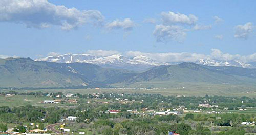
We stopped for the night in Buffalo, a very pretty town
nestled at the foot of the snow covered Bighorn Mountains. Deer Park CG is a very
comfortable and clean campground just enough on the edge of town for a
quiet night’s sleep. There are easy hiking/walking paths around the
property that offer a likely glimpse of deer. The rates ($32) seemed
reasonable for complete hook-ups, including wi-fi and cable, plus a
pool and
hot tub.
 In the morning, Judy needed to run and
Hughes needed a
place to complete a minor repair to the water intake valve of the RV.
We drove a
half hour to Sheridan, parked in a Kmart parking lot next to a county
road perfect for a 45-minute run. We both finished about the same time.
In the morning, Judy needed to run and
Hughes needed a
place to complete a minor repair to the water intake valve of the RV.
We drove a
half hour to Sheridan, parked in a Kmart parking lot next to a county
road perfect for a 45-minute run. We both finished about the same time.
We drove north and entered the waterlogged valley of
the Little
Bighorn River, where streams and creeks were running outside their
banks, and fields and pastures held great pools of standing water. In Billings, we picked up the
Yellowstone River and followed this wide, verdant valley nestled like
an artist’s painting against a line of snowcapped peaks: the Beartooth
Range, the Absaroka Range, the Gallatin Range and the Elkhorn Mountains
each provided a distinctive, jagged horizon on our left (to the
south).
Hughes thought it was time we saw Montana’s state
capital. We have been in many parts of the state on several previous
trips, but Helena
was always out of the way. It still is, but we decided that we were not
on a tight leash, so we took the detour north along US 287. It cost us
at most 25 extra miles. Hughes had heard it was a scenic drive and an
historic mining town dating back to the 19th century boom days. It was
the home of the Last Chance Placer and, in 1888, 50 millionaires—more
per capita than any city in the world! This rollicking Victorian boom
town must have been something to see back then.
Unfortunately, for a variety of reasons we were
disappointed with Helena today. There was no rollicking, no booming.
The scenery escaped our efforts to find it, the town we saw was
conventionally strippmalled, and the only campground near the
town was exorbitant, difficult to find, and run by gleefully snide
owners who knew they could get away with gouging customers (and said as
much). It was late
in the day so we bit the bullet and paid their tariff, but we’ll never
return to the Lincoln Road RV Park; Judy wrote a scathing review for
other Good Sam Club members to read and heed.
After two beautiful days of sunny weather, it rained
hard that night and we headed west out of Helena on US 12 (probably
this was the scenic route into
town) over MacDonald Pass (6,320') where
the dense clouds produced both rain and snow across Mullan Pass into Missoula. The rain picked up
again along the Clark Fork and over Lookout Pass and down into Wallace, Idaho, once a rich silver
mining center and now a charming (at least on the outside) tourist
destination with rows of Victorian buildings lining the three blocks of
its main street, including at least three incredible antique stores and
other emporia to appeal to collectors of anything western, 19th
century, or mining related. Wallace is also the hub of a number of
mountain biking trails that stretch between western Montana, across the
Bitterroots to Spokane, including the Old Milwaukee Road,
the Route
of the Hiawatha and the Coeur
d’Alene Trails. This is a prime destination for both road bikes and
mountain bikes.
With a population of about 210,000, Spokane is
Washington’s second largest city. (Surprised?). The city is large
enough to contain both Gonzaga
College and Whitworth College,
in addition to a Carnegie Library (1904), a beautiful Looff carousel (1909), the
centerpiece of Spokane’s graceful Riverside Park, plus one of the most
striking county
courthouses to be found anywhere: a Disneyesque castle more at home
along the Loire Valley than on the shore of the Spokane River. It is
also home to Auntie’s Bookstore,
a destination whenever we are in town.
We had an early dinner with Nils and Pam at the
Steam Plant Grill (converted from the original city steam plant)
followed at their home with a game or two of “Heads and Feet,” a
new card game to us that may rival Shanghai Rummy in the future.
The next day we all drove back downtown to see a
mighty
force of water pour over the Spokane River Falls, followed by a quick
browse
through Auntie’s, and a leisurely walk through Spokane’s Artfest in a
city park in the Browne Addition section of the city. Perfect weather,
good street food, a nice variety of good art pieces, and a friendly
crowd. That evening, Pam’s two children and spouses came for dinner and
catch-up conversation, mostly reminiscences of childhood times. It was
a lovely visit, one we hope they will
reciprocate with a trip to Colorado.
ON TO
CANADA
We headed north the next morning for the Canadian
border, driving along the scenic Pend Oreille (PEN-door-RAY) River
through small logging towns like Usk, Tiger, and Metaline. We had
passports, the dogs had papers, and we all had honest faces, so the
crossing was handled with ease and dispatch. We picked up the Crowsnest Highway (locally
known as “The Crow”) for the
first time, drove over Kootenay Pass (5,300') and through the fertile
valley of Creston
(forestry and agriculture, especially cherries and, some say,
marijuana!),
and home
of Canada’s popular of Kokanee beer.
Forty miles up the road we came to Cranbrook
where we stopped for the night. The Mt Baker RV Park was
centrally located and close to the Rotary
Club bike path that runs throughout the city of 20,000. Though the
path was only occasionally marked, we managed to get from one end of
town to
the other.
The next morning, we drove north and dropped Judy
off on the highway about five miles from Fort
Steele, a reconstructed gold rush boom town that originally was the
location of an early ferry across the Kootenay River. (It was never a
fort, but rather named after a popular NWMP officer, Sam Steele, and
NWMP station established there in the 1880s.) As we pushed farther
north up the valley of the Kootenay, through Skookumchuck,
Windermere to Radium Hot
Springs, the snow-capped peaks of the Rockies were a constant
reminder that winter had been long and wet, just as it had been all
over the west. In contrast, the towns along the Kootenay were decked
out in
lush green areas dominated by tourist lodgings and galleries that
appeal to golfers, skiers, fisherfolk, and sailors. There are
plenty of streams and lakes and hot springs on the western slopes of
the Rockies.
KOOTENAY
NATIONAL PARK
[Note:
In Canada it’s spelled Kootenay. In the USA, it’s spelled Kootenai.
Anthropologists now prefer and use Kutenai.
Park Canada literature
includes this last spelling in their latest brochures. First Nations
people
also refer to the Ktunaxa
language. However, the older signs and maps
continue to use Kootenay.]
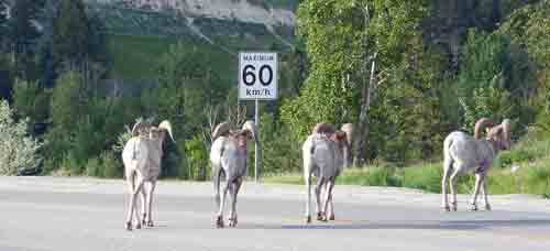
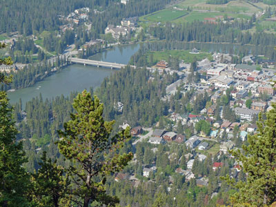
Radium Hot Springs, the gateway to Kootenay
National Park, is a laid back town of about 1,000 folks and small
roaming herds of bighorn sheep that meander through the small town. The
main activity in town is seeing to the needs of tourists who come to
ski, white water raft, fish, hike,
bird watch, and enjoy the relaxation and health benefits of the mineral
hot springs that are just a few minutes east of town within Kootenay NP.
We decided against camping at the nearly deserted and out of the way
National Park campground at Redstreak and chose instead the very
comfortable Canyon RV Park on
the banks of the Sinclair River from which we could easily walk to town
and to the
hot springs.
We hiked that afternoon to the hot springs (about
two miles up through the spectacular Sinclair
Canyon along part of the Juniper Trail and into the park) to enjoy
a few
hours of soaking in 103° mineral baths. That evening on our
walk to town we encountered several of the bighorn sheep groups that
munch grass along the highway and streets of Radium Hot
Springs. In fact, on our return, the path we took was blocked by a half
dozen or so of these full grown and probably peaceful animals grazing
along our path. With our limited experience in dealing with big horn
sheep face to face, we decided to return by a more circuitous and
prudent route. Besides, the dogs were going ballistic.
We stopped in at a Parks Canada headquarters in town
to
gather information about the six parks we were planning to visit
(Kootenay, Banff, Jasper, Yoho, Glacier, and Mt. Revelstoke): maps,
brochures, local weather conditions, and permits.
Rather than spend
$8–$9/person for a daily pass, we opted for an annual pass for $57.50
(seniors get a $10 break over the 17–64 year olds). We thought fondly
of our Golden Age passes that permit us free entry into all US national
parks and half price camping fees. All Canadians, except those under 6,
pay a fee, plus daily camping fees and special entrance fees within the
parks. Say what you will, it is a chunk of change. But then we soon
learned that most everything is a chunk of change in
Canada.
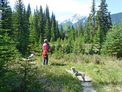
Inside Kootenay NP, we:
•Hiked to Dog
Lake. This five-mile round-trip hike
was on a comfortable trail across the Kootenay River, through McCloud
Meadows CG, and through a dense forest to a modest lake, probably good
for fishing. It did make a scenic destination and an easy first
hike for us and the dogs.
•Visited the Ochre
Beds and Paint Pots. A half mile
or so from the highway is an area where iron ore flows from springs and
the water stains the ground and mud that native people are believed to
have used for painting clothing, faces, tipis, etc. Just above this
mucky area are three nicely formed pools of gray bluish-green water
which may or may not have had any use or function.
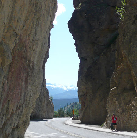
•Walked up Marble
Canyon where Tokumm Creek creek
flows into the Vermillion River. Several bridges cross and re-cross the
very narrow canyon the higher one walks to the top where the falls of
the Tokumm can be seen. Through the centuries this fast-flowing creek
has cut a slit in the
rock making a very deep and narrow chasm through the dolomite rock that
makes up
the “marble” in Marble Canyon.
BANFF
NATIONAL PARK
Canada’s oldest national park (1885) is a World
Heritage Site (along with Jasper NP, Yoho NP, and Kootenay NP). Banff
National Park is probably Canada’s most visited national park; we
were
among over 5,000,000 or so visitors this year. Originally the area
close to
the Banff Hot Springs was set aside to form a park, and was later
expanded to include
Lake
Louise and the Columbia Icefield. Tourism was spurred by the Canadian
Pacific Railway (CPR) that built the magnificent Banff
Springs Hotel (1888)
and Chateau
Lake Louise (1911). Automobiles reached Banff by 1911.
By planning our arrival before the summer swarm, we
had no difficulty finding a place to camp. In fact, we landed a
spectacular grassy site (#B72) at Tunnel Mountain II that provided a
completely uninterrupted view of Cascade Mountain (9,836'), Mt. Rundle
(9,675'), Tunnel Mountain 5,545'), the Bow River, and the Fairholme
Range. It could not have been
nicer.
[Note:
There are 13
campgrounds
in Banff NP. Tunnel Mountain, about a mile from
downtown Banff, is the largest and is divided into three sections:
Tunnel Mountain Village I ($27/night) has 613 sites with flush toilets
and showers, but no hook-ups; Tunnel Mountain II ($32/night) where we
were
has 188 sites with electricity, showers, and flush toilets; Tunnel
Mountain Trailer Park ($38/night) has 312 sites with full hook-ups. The
only other campground with electricity in the park is at Lake Louise
village (also $32/night). As we were coming into the Tunnel Mountain
area we
shuddered at the thought of over 1,100 campers crammed into a
relatively small area. The truth is that there is plenty of space, lots
of grass and trees in most areas, and we did not feel cramped at all.]
In spite of weather predictions, the skies were
filled with puffy clouds and the temperature in the low 60s. We rode
our bikes to town for stamps, postcards, and visit the Information
Centre; had the weather been moist, we could have taken a local shuttle
to
town from the campground ($1/senior each way).
The first morning, Lucy woke us earlier than usual
for an emergency trip outside. Judy returned saying how sunny it was.
An hour later, the clouds/fog settled over the Bow River Valley such
that we could not see mountains in any direction. And that was the best
part of the day! The rain that followed was not heavy, but it was
steady. Judy got in
a 45-minute run and showered before breakfast just as the rain began.
While we didn’t do and see everything, in a few
short days—and in spite of thickening clouds and rain—we managed to
visit:
•Lake
Minnewanka. This popular lake, one
of the most beautiful in the Rocky Mountains, is less than 10
minutes of paved road from downtown Banff. It is the largest lake in
the
park and has been a popular resort destination since the l880s when the
village of Minnewanka Landing served visitors until a new dam was built
that submerged the village. Scuba divers now come to explore the
underwater bridge pilings and remains of buildings. Today, it is also
popular for fishing, boating, nearby hiking and biking trails, and
excursion boat rides ($60/person). We found that even with clouds on
all sides, the setting was almost magical. We could not imagine a more
beautiful lake in the parks (but then we hadn’t yet visited Maligne
Lake, Peyto Lake, Lake Louise, or Moraine Lake).
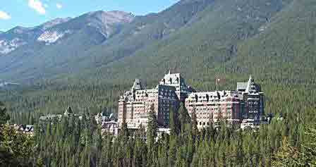
•Bow
Falls sits at the foot of the Banff Springs
Hotel and its only notable feature is that parking is free down by the
falls and you have to pay to park at the hotel, which is only a short
walk from the falls parking lot. Other than that advantage, Bow Falls
is not much
to write home about. We watched folks pile into orange rubber rafts for
what was probably a comfortable float trip down the Bow River.
Leaving the dogs in the RV for a short time, we walked up to the hotel
and through the maze of hallways until we found an affordable splurge:
coffee and scones. A few days later we viewed the hotel from the top of
Tunnel Mountain; from there, the hotel seems to emerge like some
surreal castle out of the forest that surrounds the buildings. At
$400/night and up, we thought the coffee and scones gave us sufficient
experience to say “We’ve been there.” Putting costs aside, the hotel,
fashioned in what’s called “Scottish Baronial Style” is amazing, if
cold, and worthy of one of the most beautiful mountain settings we’ve
seen.
•Canmore,
just 10 miles south of Banff, is a more
comfortable town of 12,000 folks who probably live there because it’s
less expensive than Banff yet just as scenic. There are “real” stores
in
Canmore (e.g., Safeway, Dollar Store, et al.) with none of the glitz
and high prices of Banff, and the least expensive diesel we found in
all the places we visited in Canada.
•Vermillion
Lakes has a bike path that runs
alongside the shallow lakes that are home to waterfowl and eagles.
•The
Fenland Trail is a yawn. Never mind what
the guide books say, spend your time doing something else.
•Bankhead
had been a thriving coal mining town (peak
population was 1,000) between 1903–1922. It was located between
Lake Minnewanka and Banff. The lower town (where the poor folks lived)
is visible from the road, but the upper town, where the rest of the
people
lived and where the mines were, is a short distance out of
sight of the road. Hughes rode his bike eight miles from the campground
up to the upper town (now a picnic area) and hiked a mile or so in to
see the crumbling remains of concrete buildings and a good sized mound
of high grade anthracite coal left over from the
days when the town was an important source of coal for the CPR.
•The Banff Park
Museum National Historic Site features a
collection of stuffed animals from the region, as well as specimens of
woods, plants, and minerals. The collection was put together in 1895,
long before Parks Canada put a halt to killing, stuffing, and
displaying animals. (There was also a zoo on the grounds at one time,
but
that was abandoned.) The small entrance fee ($3.40 for seniors) got us
out of the rain and a chance to see animals we would not
otherwise have seen up close (e.g., we never realized how big beavers
are) or
plants that we would never have seen. The building, it should be noted,
is constructed of logs and the interior walls are works of art for the
period and style of the building.
•Tunnel Mountain
had been in our view everyday from
our campsite. It was named for the tunnel through the mountain that was
proposed by the surveyor for CPR but never completed. The popular
three-mile round trip hike to the top on a rare sunny day gave us
excellent
views of the town of Banff and the entire Bow River Valley, plus a
360° view of the mountain ranges that surround the area.
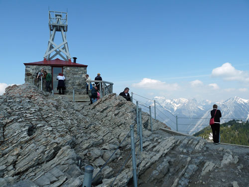
•The Banff Gondola.
The same clear day
inspired us to fork over $30/person and ride the gondola to the top of
Sulphur Mountain and continue on to the top of Sanson Peak (7,402').
The views from the top of the gondola were breathtaking for showing the
full beauty and complexity of the Canadian Rockies. It was crowded with
tourists and tour groups; we wondered what it would be like in the
middle of summer. We walked on the wood plank “skywalk” to
the top of Sanson Peak where there are the remains of a weather
station
(built in 1903) and the Sulphur
Mountain Cosmic Ray Station that was
completed in 1957 in order to study cosmic rays during the
International Geophysical Year (IGY). The Cosmic Ray Station was
dismantled and removed in 1981.
LAKE LOUISE
The Lake Louise section of Banff NP is about an hour
north of the
town of Banff if you drive the Bow Valley
Parkway (rather than the
faster 4-lane divided highway.) We weren’t in a hurry and didn’t want
to miss the wildlife—and we were not disappointed. There were dozens of
folks bicycling this particular afternoon, not because the road is
flat—it’s not flat, it’s rolling. Sometimes it has big rolls—but because the
weather was outstanding.

We found a good campsite at the Lake Louise park
campground,
said good-bye to the dogs and biked up to the lake. Just under five
miles and all uphill. Our first view of the lake caught our breath. It
is clear why the view from the east shore has inspired painters, poets,
and photographers for generations: the strangely greenish-blue water
sweeps
on both shores to a vanishing point where a glacier comes down a
V-shaped valley and fills the lake with water that appears
teal/turquoise from above. In early June,
there was a layer of thin, slushy ice along the shore but the water was
as clear as gin. We wondered if we have ever been in a more scenic
place in our lives: Switzerland? the Tetons? Yosemite? the Himalayas?
On this particular day, Lake Louise stood out above the others.
We wandered through the Fairmont Chateau Lake
Louise, a hotel that successfully contributes to the natural beauty
of
the lake and mountains. It is, as they advertise, “Elegant and polished
yet relaxed and inviting.” It is warmer and far more charming than the
cold, severe atmosphere of the Fairmont Banff Hotel: the Chateau was
designed to enhance the visual impact of the lake, the glaciers, and
the mountains with lots of windows and light, especially in the dining
area that overlooks—actually frames—the lake from several angles. But
the weather was perfect that day and we spent most of our time outside,
slurping on the tiniest scoop of ice cream we got in the hotel and at
hotel prices. Chintzy in the first word that came to us both.
We rode back to the campground for showers, dinner,
and a walk along the campground path that skirts the Bow River.
[Note:
In spite of real or imagined horror stories, we did not encounter any
flying, biting insects in Banff National Park—at least in early June.
We did
dispatch one from the RV that evening, but we think she had been with
us since Montana or Washington. We had brought some lotions and sprays
from
home,
but we wouldn’t have any reason to apply them until we found their
nests in the Okanagan Lake area a few weeks from Lake Louise.]
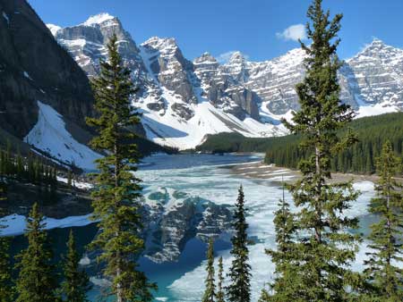
The next day we drove to Moraine Lake,
thought by
some to be the most
beautiful lake in the Canadian Rockies.
The Valley of the Ten Peaks creates a spectacular backdrop for the lake
making it an iconic representation of the Canadian Rockies. In
the first week of June this year there was so much ice on the surface
of the lake that we did not see a reflection of the peaks off
the water, but we could imagine what it will look like mid-summer. Our
son and daughter-in-law took fabulous photos of the lake on their trip
in August, 2000.
The good weather continued to hold and we had a
chance to do some hiking, specifically to Mirror Lake and Lake Agnes.
From the Chateau to the teahouse at Lake Agnes is a long two miles of
steady uphill hiking on a wide and generally smooth trail. This short
hike was made more demanding at this time because of packed snow and
ice covering the last mile. Bella and Lucy came along for the adventure
(as they did when we climbed Tunnel Mountain back in Banff). The
teahouse is a welcome oasis of comfort of warm food and drink
(waterbowls for the dogs) on their
deck overlooking the lake. It is a civilized concept that
reminded us of the gasthauses in Switzerland (and elsewhere) though
guests in Europe could spend the night as well as eat. We wonder why
they have not caught on in this country.
A half mile before the teahouse we paused at Mirror
Lake, a small but scenic lake formed from the spillover from Agnes
above. At Mirror Lake the trail forks: we could have taken the left
fork which leads to the Plain of Six Glaciers, but that was another two
and a half miles with the trail becoming even more treacherous because
of deeper snow and ice. Our son and his wife hiked there on their trip
to the area in August, 2000. It is
an incredibly beautiful area also. However, given the snow and ice, we
didn’t think twice about taking the right fork leading to Lake Agnes.
We had such remarkable vistas from the top of the
Banff gondola, we thought we could duplicate the experience at the top
of the Lake
Louise gondola. What a disappointing experience; it was not nearly
as pleasant, as informative, nor as scenic as Banff’s. The ride got us
near the top of their local ski area and dropped us off. We took a few
photos, but had no other reason to stay. Of course there were no
grizzlies to be seen in spite of the seductive possibility suggested in
their advertising brochure. All in all, we should have spent our money
elsewhere.
[Note:
We know that other campers have not given high grades to the campground
at Lake Louise, citing noisy trains (occasionally) and bathrooms that
were not very clean (we disagree). The setting along the Bow River is
spectacular, the snow-capped peaks can be seen from most sites, and
there
is a wide, flat path that follows the river from the campground to town
(about
a mile). Except for an occasional train (not at all unusual in any part
of Canada we were in) it was quiet. We’ll carry the image of the
mountains, the river, and the path with us all the way to our next stop
in Jasper.]
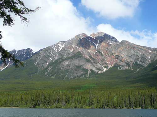
ICEFIELD
PARKWAY, PART 1
The 142 miles from Lake Louise to Jasper takes
visitors along one of the most dramatic highways in North America. The
Icefield Parkway passes waterfalls, lakes, glaciers, and
ever-changing
mountainscapes around every bend in the wide highway. Along the
way there are many opportunities for short or long hikes,
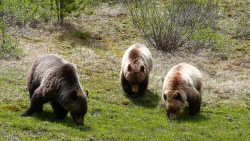
as well as remarkable scenery to photograph. Mile by mile we stopped at:
 •Mile 10: Hector
Lake, just ten miles from the
beginning of the parkway, is really too far off the highway to
photograph from the pull-out area. We tried anyway. However, shortly
after we pulled back into traffic, we saw groups of cars on both sides
of the road: a sure sign of a wildlife sighting. Not more than 40 yards
off the east side of the highway was a lone black bear quietly munching
on
berries and grass.
•Mile 10: Hector
Lake, just ten miles from the
beginning of the parkway, is really too far off the highway to
photograph from the pull-out area. We tried anyway. However, shortly
after we pulled back into traffic, we saw groups of cars on both sides
of the road: a sure sign of a wildlife sighting. Not more than 40 yards
off the east side of the highway was a lone black bear quietly munching
on
berries and grass.
•Mile 20: Crowfoot Glacier
is just ten miles
further and offered a glimpse of what we would see by the time we
reached the Icefield Center.
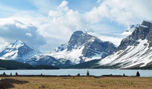
•Mile 23: Bow
Lake (on the left) is the third largest lake in
Banff NP beautifully set at the base of Bow Glacier. On the east shore
is the rustic historical Simpson’s Num-Ti-Jah
Lodge built in the 1920s and
still run by the Simpson family. As we hiked alonog the shore, we
noticed there was still a layer of
ice all around the lake, though the trail was generally dry. Staying at
the lodge is a bit pricey, but the rustic exterior gives way to a
comfortable dining room and creature comforts inside, including
satellite TV so current occupants would not miss any of the Stanley Cup
action.
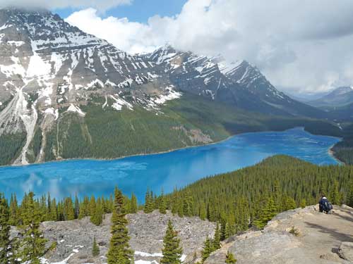
•Mile 25: Peyto (pea-toe) Lake,
just around a bend
from Bow Lake, is another (#3) of the five
most beautiful lakes in the
Rockies because of its teal/turquoise water fed by glaciers in the
area. The photos we took overlooking the lake (see below) looked as
though they’ve
been touched up, but be assured the color is real.
•Mile 44: Mistaya Canyon
is an impressive slit in the earth carved through the limestone as the
Mistaya River has sliced a
deep,
narrow gorge through the rock. The swirling action of the water has
scooped our whirls and potholes in the rocks that are now well above
the water level. The half mile walk is an easy climb and well marked.
•Mile 64: The
Icefield Centre marks the halfway
point between Lake Louise and Jasper. The expanded Visitors’ Centre
faces the Athabasca
Glacier, the most visited glacier in North America, and can be
accessed by foot (to the “toe”
of the Glacier) or by guided tours in a SnoCoach with proper equipment.
The Centre has informative displays on glaciers in general and the
massive icefields that visitors can see across the highway.
We had planned to drive directly to Jasper from the
Icefield Centre in order to
secure a campsite with electricity at Whistlers
Campground. We decided
that any attractions we missed in the northern half of the Icefield
Parkway we would see on our return.
JASPER NATIONAL
PARK
There are thirteen campgrounds in Jasper
NP, but only
Whistlers and Wapiti have hook-ups. There were no powered sites at
Whistlers by the time we got there mid-afternoon, so we spent the first
night across the highway at Wapiti, a paved parking area with
electrical outlets. The next three nights we moved over to Whistlers
which has treed sites (fir, pine, and spruce) in the heart of bear
country and where elk cows are calving their young. In spite of having
nearly 800 sites, it is a very quiet area with lots of space between
campers, and less than two miles to town.
[Note:
Each of the three campgrounds we stayed in at
the two parks (Banff NP and Jasper NP) have a different policy on
campfires:
Jasper provides each site with fire pits and firewood at no charge;
Lake Louise charges $8/night for a site with a fire ring, but the
firewood is free; Banff permits fires only in selected sites, but we’re
not sure about any charges. Ask when you pull in.]
We loved the town of Jasper!
Unlike glitzy Banff and tiny Lake
Louise village, Jasper is a town of just over 4,200 people who, at
least all the ones we spoke to, love living there. It is surrounded by
stunning mountains on all sides, yet is open and filled with parks,
bike paths, stores and services that don’t seem too proud of
themselves. The owner of the first store we stopped at to ask about a
laundromat was friendly and polite; he took time to give us a
map, showed us our choices, identified two grocery stores, and said he
hoped we would enjoy our stay. What a lovely start. We did our laundry,
passed up tickets for a Rotary Club lobster dinner that evening
($55/ticket for a full dinner with all the trimmings), and dined “at
home” and rested.
In the morning, Judy did a “Sunday morning” run—an
hour run just as she would if she were in Boulder. Afterwards, our
first destination
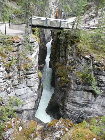
was a drive north and east of town to the Maligne (mal-EEN) River
Valley. We hiked along the Maligne
Canyon, a steep-walled limestone
slit in the rock the river has carved our to a depth of 180' through
the limestone karst.
The trail (a mile and a half each way) crosses the
river six times as we walked upstream to the deepest section near the
first bridge.
After lunch at the trailhead, we drove on to
Medicine Lake,
described as a “most peculiar” lake—a sinking lake,
since the Maligne River “flows” underground for many miles until it
emerges at Maligne Canyon near the 4th bridge. The holes (sinks) in the
limestone make the lake like a leaky bathtub, allowing the lake to
drain at a rate of over 6,300 gallons per second! When we saw it, the
water level was down significantly. Some seasons water flows in
faster than it can “leak out” into the bedrock which causes the lake
level to
rise. At other times the “lake” is a gravel wasteland with a shallow
trickle running through it. The Maligne
Karst System, we learned, is one
of the most studied in the world.
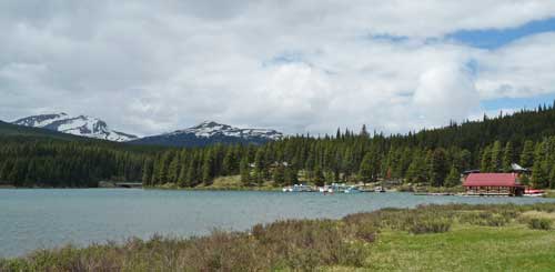
Our destination was Maligne Lake, (see photo on the
right) the largest lake
in the
park and one
of its most beautiful: nearly 14 miles long and half a mile wide.
While it is fed by
melt water from the Brazeau Icefield 18 miles to the south, it does not
have the turquoise color associated with glacial melt (like Lake Louise
or Peyto Lake). However, it is a stunning area that has been popular
with visitors for fishing and boating, as well as hiking, for over 100
years. The 90-minute cruise ($57.75/person) has been described by
Reader’s Digest as “the best
cruise in Canada.” We chose to walk the
shore along the Mary Schaffer Trail for great photos.
We spent a morning window shopping and had lunch at
De’d Dog Bar and Grill (part
of the historic Astoria Hotel—very tasty, reasonably priced, very
friendly
waitress/bartender, and free wi-fi). We’d go back again in a heartbeat.
We drove 24 miles to the northeast entrance to the
park
at Pocahontas
(a coal mining ghost town that boomed in the 1920s)
to indulge ourselves that afternoon relaxing in the mineral waters of
Miette
Hot Springs. It was interesting to be surrounded by groups of
mostly seniors who spoke probably ten different languages:
French, German/Austrian/Swiss, plus languages from eastern Europe and
Scandinavia. Both days (in the Maligne River Valley and along the
Fiddle River to the hot springs) we saw grizzlies and several herds of
mountain goats by the roadside. We had not, nor would we see, a moose
(very shy?) or caribou (not too many and they’re still up high?).
Our last day in Jasper we spent biking through and
around the town, shopping for some last minute necessities (groceries,
beer, four screws, and a fuel fill ($94 for 83.8 liters [22.1 gallons]
at $1.12/litre [about $4.28/gallon]).
We drove above the town to Patricia
Lake where a local
dive shop gives lessons and takes divers down to the wreck of one of
the strangest ships in history that was purposely sunk in the lake
during World War II. The story of the top secret ship made of ice
(called “Operation
Habbakkuk”) was an experiment that had the approval
(or at least the interest) of Winston Churchill as a means to move
goods and troops safely across the Atlantic (they wouldn’t attract
magnetic mines and would be more durable than conventional ships). A
large scale model was created and tried out on Patricia Lake and, while
it proved feasible, it was determined to be too expensive to be
practical. So the wood frame of the structure was sunk in the lake and
divers now use it as scuba destination.
Just around the corner from Patricia is Pyramid
Lake, a serene lake with a small island connected to the shore by a
walking bridge. We could just make out Mt. Edith Clavell shrouded in
clouds (and access closed because of snow and avalanches) to the south,
and Pyramid Mountain (below) with its surprising gold/bronze surfaces
reflecting in the morning sun. The distinctive color comes from Gog
quartzite which has particles of iron pyrite embedded in it.
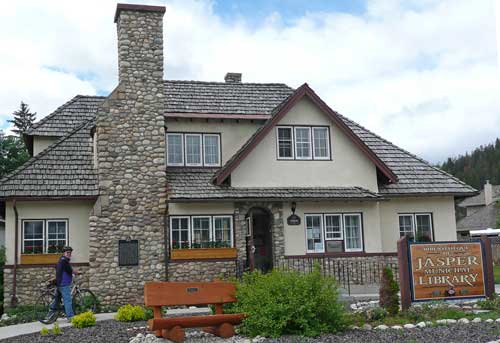
We biked an easy 8K on the “Discovery
Trail”
(partially paved, part gravel, part neighborhood streets) to
photograph some of our favorite buildings in Jasper: the Visitors
Information Centre, fire station, Lutheran and Anglican Churches, and
the library, where we encountered the coldest, least informed, least
helpful, least interested librarian in all of Canada. ‘Nuff said.
[Note:
Its, It’s, and Its’. If you’re over 40 we’re
pretty sure you were taught in the 4th grade that /its/
is a possessive
(i.e., belonging to it) and /it’s/
is a contraction (it + is). /Its’/
is a misspelling. You see the confusion and misuse of /its/ and /it’s/
more and more frequently in newspapers and magazines and in personal
writing, probably due to over-dependence on spell checking software
coupled with lazy, ignorant, sloppy, or non-existent copy editors. (We
hope we've been careful in this article!) However, we’ve begun to
notice it on
public signs, plaques, and other official
documents while traveling in Canada (and in this country we must
acknowledge). It’s shameful when it’s misspelled on road signs or TV
ads, but we’ve seen it on engraved plaques in parks and on buildings.
The librarian in Jasper said no one has ever mentioned anything about
the misspelling of /it’s/
for /its/
on their memorial plaque embedded
in the exterior of the building, and if it were mistake (and she didn’t
think it was) they wouldn’t do anything about, now would we? No
matter—its (sic) a beautiful library.]
We biked out of town to Lake Edith and Lake Annette,
two small lakes each with picnic sites and access to the water. Our
last stop was the Fairmont
Jasper Park Lodge, another in the Fairmont chain though not as
ostentatious as most others in the Fairmont family.
Jasper’s Fairmont is constructed in a
rustic log style spread out along the banks of the Athabasca River and
generally out of sight of town. The golf course would make almost
anyone want to take up the game just to enjoy the beauty of the course;
Score Golf magazine rated it
last year as Canada’s #4 Best Golf Resort,
in spite of being heavily populated with grizzlies and elk, both of
which were bearing their young. (For the protection of the golfers or
the animals, there is a high, strong wire fence surrounding the
course.) Bear bells, golfers there know, simply don’t do the trick; the
bells are ultimately a harmless tourist souvenir that are helpful in
locating bears after they’ve eaten the tourists: the bears jingle when
they move.
We got back to the RV parked in town to feed and
walk the dogs prior to a local and very informal weekly 5K race that
usually draws anywhere from 10–30 runners. While Judy did not come in
first, she won the overall 30-up age group.
[Note:
Robertson
Screws.
We wanted to get a couple
of screws to put up a bulletin board in the RV. A fellow in a hardware
store in Jasper said I could take a
couple from one of the bins of bulk screws. No charge. I said “Many
thanks,” took a couple and put them in my pocket and rode my bike back
to the campground. A couple of days later when we remembered we wanted
to mount the bulletin board, I discovered the screws were neither
slotted screws, nor Phillips head screws, but Robertson screws! They
are all over Canada and it’s next to impossible to find any other kind.
Stores sell a few Phillips heads for hanging drywall, but the rest are
Robertsons. I’d never heard of them nor seen one. But they are the
screw of choice in Canada. The history of
Mr. Robertson’s screw (and other types) is
fascinating and worth a minute to learn about it.]
ICEFIELD PARKWAY
PART 2
Our return trip south on the Icefield Parkway was
cloudy (mostly) and moist (occasionally). The photographers for Parks
Canada who produce the mouthwatering brochures must have to wait days
in July through September for the perfect combination of bright
sunshine and puffy clouds or clear blue skies. Patience in a virtue of
good photography. Travelers like us take what we can get and use our
imaginations to fill in the beauty spots. We made the most of the
stops we wanted, but decided to bypass some others because of really
poor weather. We made several stops between Jasper and the
Icefield Centre, places we intentionally passed over on our way up:
•Athabasca
Falls is a short hike from the highway.
Approaching this amazing waterfall, we could feel the tremendous force
of the Athabasca River (which carries more water than any other river
in the Rocky Mountain Parks) as it swirled around the resistant rocks
in the gorge. It drops 75 feet over an outcropping of highly
resistant
Gog quartzite.
•Suwapta
Falls is just eight miles below Athabasca
Falls and is similar in formation and appearance to Athabasca Falls.
•Tangle
Falls can be easily missed by travelers since
there is no sign alerting drivers to its location. A fellow who works
for a Banff art company also stopped for photos and told us it was
first time in the years he’d been making the Banff–Jasper run that he’d
stopped after he saw us taking pictures. Tangle Falls is a classic
cascade of water that is featured in several travel publications. It is
a good photo op for someone with variable lenses to catch different
portions of the water as it flows over rocks in several steps.
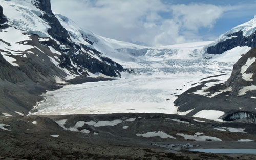
•The Icefield Centre was the final stop to hike out
to the toe of the Athabasca
Glacier. Signs claim that it’s the most
accessible glacier in North America, though we found several in Alaska
as easy to get to (e.g., Exit Glacier near Seward). Barriers and signs
warning of the dangers of walking on surface of the glacier (hidden
crevasses, falling, etc.) face those who approach the glacier. The
story of a nine-year-old boy who ventured onto the ice behind the
barrier and died falling into a crevasse was prominently posted, as was
the
fact that the last three rescue attempts failed. Organized groups are
transported by “ice tractors” onto the glacier above the walkers’
trail. These groups are given yellow waterproof pants and jackets, ice
axes, and crampons for walking on limited portions of the glacier.
YOHO NATIONAL
PARK
Yoho NP is a picturesque extension of Banff NP and
Jasper NP into British
Columbia and is part of the Canadian Rocky Mountain Parks
World Heritage Site . Like Kootenay NP which borders on
the south, its fortunes were tied to building of railroad lines across
the Rockies in the 1800s. Yoho is not without some diversity of scenic
beauty, but if the railroads had not wanted to have safe passage
across to British Columbia, Yoho may never have been developed as it
has. (The same can be said of Kootenay NP.)
There are fewer unique attractions than in Jasper
and Banff to claim a traveler’s interests. In less than a day we
visited:
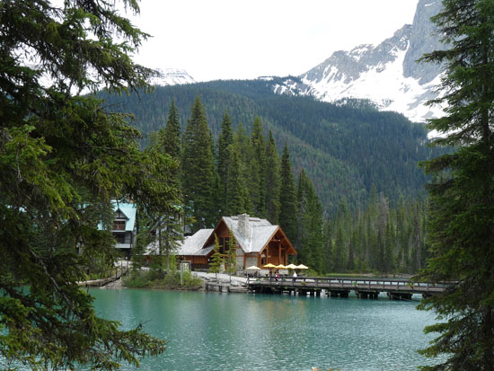
•Emerald Lake.
This small jewel sits in a lush forested basin enclosed by Mount
Burgess, Wapta Mountain, and the
President Range that collects snow melt and frequent rains in the
summer. We were fortunate to have fair weather to hike the three-mile
loop around the lake enjoying the wildflowers that had just begun to
emerge. The first half of the path is flat, wide, and smooth; the trail
narrows and proceeds through a rather soggy, shady area on the east
side. Plank boardwalks help to keep the feet dry, but only a little.
The Emerald Lake Lodge (with facilities for conferences, weddings,
etc.) enhances the
romantic mood of this near pristine area.
[Note:
Within two weeks after our visit,
there were two separate grizzly attacks on groups of hikers on the
hiking trail we had completed. No humans were killed, but the bears
eventually were captured and Parks Canada were, by policy, forced to
put them down.]
•The Spiral Train
Tunnels, an engineering challenge
that permitted trains to descend the steep western slope into the
Columbia River Valley, are likely of interest to hard core train buffs.
We were lead to believe that the road to Takakka
Falls was temporarily closed to public access. It may be that we
misread the signs, which in all the parks is often easy to do;
throughout the Canadian parks we visited, signs are damaged, illegible,
or, worse yet, missing.
[Another
disappointment was not stopping in the middle of the park at the
small town of Field, which houses the museum that features fossils from
the nearby Burgess
Shale fossil beds. The
importance of the fossils, many of which are exceptionally preserved
soft parts, was the focus of Wonderful Life
by fellow Antiochian
Stephen Jay Gould (also class of ’62) that showed that life forms then
were
much more diverse than today and that many lineages were “evolutionary
experiments” that became extinct. Public access to the fossil beds is
severely restricted, but the museum is said to be excellent.]
We spent the night at Golden
Municipal Campground
operated by the city of Golden, BC. An excellent walking/running/biking
path parallels the Kicking Horse River on “our” side of the river (the
train runs along the other side of the river). Judy got in a long
run after dinner. We should have suspected that though trains may not
stop, they do make their presence known to campers and the rest of
town. We biked around this small town, shopped at a local produce and
craft market, caught up on days of emails, and watched game seven of
the Stanley Cup finals. There were lots of disappointed Canadians that
evening; the hooligans that wrecked downtown Vancouver were an
embarrassment to everyone we talked with in the weeks that followed.
We woke to thick low clouds that hung over the town
of Golden and the mountains to the west that we would travel through to
visit the last two Canadian national parks on our itinerary. We were
able to see only half the parks: the bottom halves.
GLACIER
NATIONAL PARK
Canada’s Glacier
NP was created in the 1886 to
protect over 400 glaciers within its boundaries and to add new
preserved land along the Canadian Pacific Railroad. Because of what
rangers at the Rogers Pass Information Centre called a “very late
winter” in the entire Canadian Rockies region, many areas were not
accessible due to snow and avalanches.
•The Loop
Brook Trail was one area we could hike.
This self-guided interpretive trail follows a section of an
old CPR train bed with old photos and information emphasizing the
hardships faced by the workers who built the railroad through this
area. The massive stone trestle supports are amazing testament to the
efforts
of to bring the railroad to this area.
MOUNT REVELSTOKE
NATIONAL PARK
Mt.
Revelstoke NP is a small park that was added to Parks Canada in
1914 to
protect more railway as it crossed the Selkirk Mountains to the
Columbia River, and features two attractions: The Meadows-in-the-Sky
Parkway and a
grove of old-growth cedars and hemlocks. The Parkway begins at the town
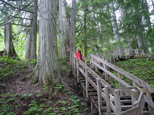
of Revelstoke, so stopped on our way to town to see the trees.
•Giant
Cedars Boardwalk is a short self-guided
interpretive boardwalk through a small grove of old growth western
hemlocks and western red cedars that are over 500 years old. The
section of temperate rainforest is thick with devil’s claw and fern.
It is a perfect walk during rainy weather: there’s no mud and the dense
forest provides protection from the rain.
We drove down to the very pleasant town of
Revelstoke,
found a comfortable site at the Lamplighter Campground
close to town. The rain persisted through the afternoon so we made
plans to drive the 16-mile Meadows-in-the-Sky Parkway in the
morning—weather permitting.
However, it rained off and on all day. While it rained we did
maintenance inside the RV. When the rains stopped, Judy got in a run on
and, later, we rode our bikes on Revelstoke’s “Discovery Trail” that
led us along the banks of the Columbia River. We shopped town, picked
up some groceries, and gave up on driving up the Parkway.
It rained all night and in the morning the grassy
campground was
soaked. We pulled out promptly in order to hit the farmer’s market in
town for fresh produce (the leaf lettuce and arugula had just been
picked and
washed that morning) and scones with which we could finish our coffee.
A stop at grocery for some manufactured staples and we were on our way
south on lonely Highway 23, heading for Nakusp
(rhymes with the-CUSP)
where we learned there was a hot springs and an adjoining campground.
[Note:
We hadn’t
seen so many slugs before. Once out of the high mountains we
found ourselves hiking and camping in areas not unlike an interior
rainforest (like the Olympic Peninsula except well away from the
ocean). Mosses are thick, the ground is soft, and there are areas where
you can find thousands of black slugs
underfoot, in the grass, on the
road, etc. They don’t bother anyone, unless you step on them. The dogs
are not interested. They don’t move fast and don’t make noise. Some
claim they’re icky!]
KOOTENAY
ROCKIES
In between Revelstoke and Nakusp was a 15-minute
ferry across a very wide place in the Columbia River from Shelter Bay
to Galena Bay. The ferry ran from our side to the other each hour on
the hour. We were there at 10:10 and had 50 minutes to wait, just long
enough for Judy to get in a morning run. She headed back the way we
drove down and hadn’t been gone 15 minutes when a ferry arrived,
dropping off half a dozen vehicles. The captain announced the ferry was
leaving in three minutes. It turns out this ferry was a “small” one
that runs only in the summer on the half hour. Meanwhile a couple
arrived to
get into line and said they’d seen Judy on the road. They’d also seen
at least one bear on the same road, but not near where she was running
at the time. “Not to worry. I’m sure she’ll be OK,” said the young
woman. Easy for her to say! It turns out she was right: Judy returned
five minutes before the ferry left. She had seen a fox, but no bears.
The rest of the drive to Nakusp was quiet: no towns
and
very little traffic. As we approached the outskirts of Nakusp we
followed
the signs to Nakusp
Hot Springs which, it turned out, is about eight
miles up in the mountains along the Kaskanax Creek, a wild stream the
thunders down from above the hot springs, past the campground, and
plunges down into the Columbia River at the town.
The small, isolated campground
was nearly deserted
and there were fewer than five soakers in the pool. We were a bit
ambivalent about staying. However, we were glad we made the choice. The
facilities, owned and operated by the town of Nakusp, were sparkling
clean, the
folks who worked there were very friendly, and the campground was
nicely located on the banks of the Kaskanax Creek. We hiked a mile or
so up the creek, past a rushing waterfall, to a small meadow where the
hot water comes out of the ground and is piped to the pool below. We
saw the remnants of the concrete tubs that were the original “soaking
pools,” now surrounded by a fertile field of poison ivy. We soaked away
the afternoon under warm sunshine in the two pools (one at +104°,
the other a 103° or less). The forest setting was equally relaxing;
there were few people, no train whistles, no barking dogs (except
ours), and no traffic.
The small town of Nakusp (pop. 1,500) sits like a
picture postcard on the shores of Upper Arrow Lake, which is part of
the Columbia River. We were disappointed when we drove down the main
street on a Sunday morning; the “cute” brochure photos featured
only the waterfront, which was really quite attractive. We enjoyed
walking on the well-maintained shoreline sidewalk. past the
“Japanese” gardens which were in full bloom, having had a generous
natural watering
and enough periods of sunshine to encourage growth. The view
across Upper Arrow Lake reminded us a great deal of the Alaskan coast
without the rain: low clouds and mountains that rise steeply from the
dark water on all sides. Away from the waterfront were a few active
businesses, some commercial vacancies, and little activity.
[Note:
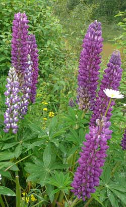
Lupines seem to be everywhere. These beautiful flowers can be
seen growing wild along the highways throughout the river valleys
between the Purcell Range, the Selkirks, and the Monashee Range.
The blooms are usually about two feet high, come in a range of
colors, and brighten the monotonous green of roadside vegetation.]
[
South of Nakusp is New
Denver and, a few miles
beyond that, a good dirt road (today it was muddy but firm) that we
followed to
the ghost town of Sandon, a
silver mining town that boomed at the turn
of the century (i.e., around 1900). Where once lived 5,000 wild and
hard working miners, gamblers, saloonkeepers, and various other members
of a typical western mining town, now 15 folks attempt to eke out a
living in an area they call home. They tend to the Sandon Museum,
maintain the oldest electric power station in British Columbia, sell
various snacks and souvenirs to tourists at the general store (once
city hall and the fire station), and take care of Molly Brown’s Brothel
that has been lovingly restored. During WW II, like other towns in the
region, Sandon
was an internment camp for
Japanese-Canadians, though there are no visible signs of this
period. Derelict buildings that escaped the 1900 fire and
the floods of 1925 and 1955 are scattered along and above Carpenter
Creek. By 1962 the post office closed, a familiar sign that the town
was pretty much gone ghost. Visitors today will be surprised to find a
small fleet of Vancouver trolleys carefully parked awaiting
restoration.
Highway 6 continued to Kaslo
(pop. 1,000), a pretty
and apparently thriving resort town on a bay overlooking Kootenay Lake
(it looked a lot like Ketchikan or Sitka). As we drove through we were
very tempted to stop, maybe even spend a night, if only the weather had
been drier.
We caught the ferry at Balfour (pop. 500), also a very
scenic resort town farther down Kootenay Lake, to take us
across to Kootenay Bay. We drove on to Crawford Bay,
a center for
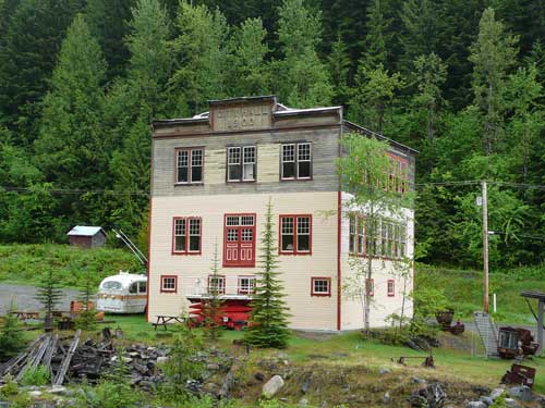
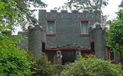
artists and crafters, and down to Boswell, home of the well known
Glass
Bottle House. This remarkable building was built of half a
million empty embalming fluid bottles by retired undertaker David Brown
between 1952–1970. The castle-like building was the family home and is
still used by the family during the off-season. Hughes’s sister
insisted we
should pay a visit and we were not disappointed. We’ve since learned
there are a surprising
number of bottle
houses still standing throughout
the world, though most seem to be in North America. We have seen one
other (only because we didn’t know about ones in towns where we’ve
traveled): the less elaborate bottle house in
Rhyolite, Nevada, built
by barkeeper Tom Kelly from 51,000 bottles (mostly Busch beer, but
includes some
medicine bottles).
[Note:
I’ve always had trouble quickly converting
Celsius to Fahrenheit. I remember from 8th grade science that Mr.
Matiasz gave us a convoluted formula that used 9/5 and/or 5/9 to make
the transposition. It never stuck. The guide at the Bottle House gave
me a quick rule of thumb: multiply Celsius by two and add 30. It’s not
perfect, but close enough.]
We drove back to the ferry to return to Balfour and
make the drive to Nelson
(pop. 9,000), one of the favorite towns we
visited in British Columbia. We found the centrally located Nelson
City
Campground on High Street one of the bargains on our trip: $22 for
all
hook-ups, wi-fi, showers, laundry, kitchen facilities for campers, and
a couple of non-cable TV stations. It was clean, comfortable,
supervised by fabulous hosts; it offers visiting RVers and tenters an
attractive incentive to come to Nelson and spend time (and $$).
We woke our first morning in Nelson to the bluest
sky of the entire trip. Judy ran on a great pathway along the
waterfront and through downtown. Later we shopped the bakeries: we
discovered Oso Negro coffee
and outstanding scones at The Only
Bakery (apparently they are too busy making great scones to get a
website up and running),
bookstores (found a great book on BC ghost towns, but didn’t
write down the title!) sports shops, and enjoyed the variety of
architecture in downtown stores and neighborhoods.
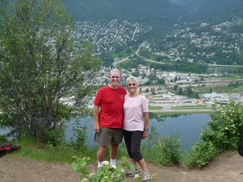
We left the dogs at the campground and biked across
Kootenay Lake to the trailhead for a hike to Pulpit
Rock, a very steep
one mile (it seemed much longer!) to a vista overlooking the city. We
had great views of Nelson
and the surrounding area, plus we could see the dark clouds coming from
the south that threatened to cast their shadow (and rain) over the
town. We took our photos, made our way carefully down the steep descent
to our bikes and almost made the three mile ride back to the campground
before
things got very wet. We did laundry and showered, had dinner, and
hunkered
down while the rains washed the streets of Nelson.
Getting to Kelowna from Nelson usually means driving
south to “The Crow”
(Highway 3), west to Osoyoos, and north to
Kelowna—about 160 miles. Instead, we chose to drive 240 miles back to
Nakusp through Silverton and New Denver along the Slocan (slow-CAN)
River, then south to the ferry at Fauquier. (We never heard anyone
comfortable pronouncing that place name in our presence. The best
suggestion we
know is to say “folkier,” which is close enough and easy to remember.)
From the ferry we drove over the Monashee Mountains to Vernon and on to
Kelowna. Why the
extra 80 miles? To complete our “tour” of the Slocan Mining District,
especially to see BC’s Silverton and how it stacks up with the
Colorado town of the same name.
North of Nelson is a fertile farming area along
the upper part of Lake Slocan. Lots of gardens, but fewer livestock
than we would have thought. We pulled off to drive through the tiny
village of Slocan
(pop. about 325), at one time the smallest incorporated
city in the British Commonwealth. It was once a booming silver
producing town; later it was a internment center for Japanese-Canadians
during
WW II
(geneticist David Suzuki was incarcerated there from 1942–45); now it’s
a logging town with neat houses, many community facilities, a nice
school, etc., typical of a company town supported by the logging
operation.
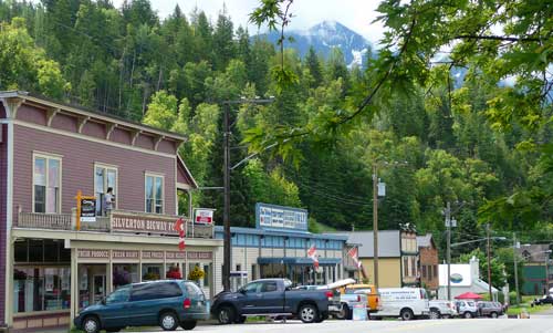
Silverton
(pop. about 200) was, like our Colorado
namesake, built on silver mining. The setting, however, is quite
different: where
Silverton,
Colorado, sits at 9,300' surrounded by 12,000' peaks, the
BC version sits on the east shore of Slocan Lake. Both towns are
small and just hanging on financially, though the Durango to Silverton
Railroad still holds the Colorado town back from the brink of
bankruptcy.
New Denver (pop. 600) shares its history with Slocan
and Silverton: silver boom in the 1880s, followed by huge decline in
population, and then an interment center during WW II. One difference
makes New Denver stand out: The residents of New Denver created and
maintain a Nikkei
Internment Memorial Center where about 22,000 people of Japanese
descent, labeled “enemy aliens” by virtue their heritage (never mind
their Canadian citizenship) were confined. Original houses and a
beautiful Japanese
garden make stopping there worthwhile.
[Note:
In the 1950s, children of the “Freedomites,” a Doukhobor
group were forcibly removed from
their homes by the government and confined to a boarding school in New
Denver because their parents refused to send their children to school
due to religious beliefs.]
OKANAGAN
AND BOUNDARY COUNTRY
The remainder of the trip to Kelowna
required
another ferry transport at Fauquier and and a long, lonely drive on a
twisting mountain roadway surrounded by forest and
crisscrossed with streams rushing down and under the highway. There was
very little traffic until we reached Vernon (population 50,000) where
we felt the stinging slap of civilization after two weeks in wilderness
and
small towns. We arrived finally in Kelowna (population about 120,000),
called
by some “the closest you can come to California in Canada.” We suppose
it’s true; there are orchards and gardens everywhere, and there are
over two dozen vineyards in the valley.
We stopped for a couple of days to visit with Ron
and Edna, friends we’d met in Tucson during the winter. Their house
borders the Myra-Bellvue
Provincial Park and overlooks the town of
Kelowna and Okanagan Lake. We visited a farmer’s market
in town and went to lunch at Summerhill
Pyramid winery that overlooks
the city. We followed
lunch with a wine tasting: reds, whites, sparkling, and dessert wines
from which to
choose. (Hughes can testify that Summerhill’s “Diva’s
Delight” is one of
the finest late harvest/dessert wines he has ever tasted.)
The dogs got their walk in the afternoon, and we
relaxed on the porch with Ron and Edna and enjoyed candied salmon with
our cocktails.
After dinner, Ron drove us up to the top of Myra
Canyon where the
tracks of the Kettle
Valley Railway, built in 1915 and abandoned in
1961, are close by. This railroad is the foundation for a network of
nearly
375 miles of pathways for use by hikers and bicycles throughout
southwestern British Columbia. The area in Myra-Bellvue Park
suffered a wildland fire in 2003 that burned 13 of the 18 trestles in
this area, which were restored five years later. We walked
to the first trestle of the Myra Park section
until the mosquitoes, the first we’d encountered on the trip, drove us
to the safety of Ron’s truck.
It rained hard that night, but when we left the
following morning we could see patches of blue and the skies cleared by
mid-morning.
We passed south of Kelowna through the vineyards of
Summerland, stopped along the splendid waterfront Penticton
(pen-TICK-ton) at the south end of the lake, passed quickly through
Okanagan Falls, turned east at Osoyoos,
and up into the mountains where
an outfit called Regal Ridge is buying land and building mountain
estates like
crazy. Down the other side of the hills we passed through farming and
former mining towns like Rock Creek, Kettle Valley, and Midway.
[Note:
Osoyoos marked our return to the Crowsnest
Highway or “The Crow” (Highway 3) that runs between Hope, BC and
Medicine Hat, Alberta, the shortest distance between the Pacific and
the Prairies. Its name is from Crowsnest Pass that was a route through
the southern Rockies. We were to follow that all the way to Creston
where we eventually went south to the US border.]
We arrived at Greenwood
in the early afternoon and
knew immediately that we should linger here. It felt very comfortable
like a (former) Colorado mining town. Miners once dug a lot of
copper out of the earth nearby, the British Columbia Copper
Company’s
smelter ran 24 hours a day, and the Columbia & Western Railway
built
tracks to Greenwood in 1899 to haul it all away. It was once one of the
largest copper
producing areas in the world. But production fell off before WW I and
the smelter closed; the population dropped from 3,000 to about 200.
Even today, with a population of 600, Greenwood is Canada’s Smallest
Incorporated City.
When the Second World War came, the mayor of
Greenwood requested that
Greenwood become a camp for Japanese-Canadian
internees. The folks of Greenwood generally welcomed 1,000 of their
fellow
Canadians, got along well with them, and when the war was over and the
government’s policy was to remove the Japanese-Canadians east of the
Rockies, the folks of Greenwood voted to request that they be allowed
to stay. Many did and transformed the character of this tiny city. The
person in charge of the visitors center, at least when we visited, was
of Japanese descent, perhaps old enough to have been a member of a
family once interned at Greenwood.
We found a small RV park with lots of green grass
and only one other camper at the back of the Greenwood
Motel and RV
Park ($23/night for hook-ups, wi-fi, and cable TV) just two blocks
from
“downtown.” In many ways, it may have been the nicest place we stayed
on the trip. We walked through the town, taking photographs of the
churches, downtown storefronts, the post office, public swimming pool,
and many marvelous Victorian homes most still in good repair. However,
it’s clear their best days are behind them: there’s no work, no grocery
store or pharmacy, no high school, and most folks we were told are
either on senior pensions or getting poverty support. We saw many homes
and businesses for sale.
There is a chance that tourism may grow as outdoor
enthusiasts discover great biking, running, and hiking on the Trans Canada
Trail
that goes through town; or hiking, kayaking, fishing, and cross-country
skiing nearby and in two provincial parks in the area, Jewel Lake and
Boundary Creek; or downhill skiing on Phoenix Mountain; or driving
tours that offer a glimpse into Greenwood’s mining history. Judy had a
morning
run on the Trans Canada Trail (which is really network of nearly 400
trails that cover over 11,000 miles and crosses the country from
Newfoundland to Nunavut and the Northwest Territories). She said it was
wide, flat, and a joy to run on.
 [Note:
The town of Greenwood is featured in the
movie “Snow Falling on Cedars,” which was filmed there in 1998. The
movie, ironically, is the story of deep anti-Japanese prejudices that
remained following WW II.]
[Note:
The town of Greenwood is featured in the
movie “Snow Falling on Cedars,” which was filmed there in 1998. The
movie, ironically, is the story of deep anti-Japanese prejudices that
remained following WW II.]
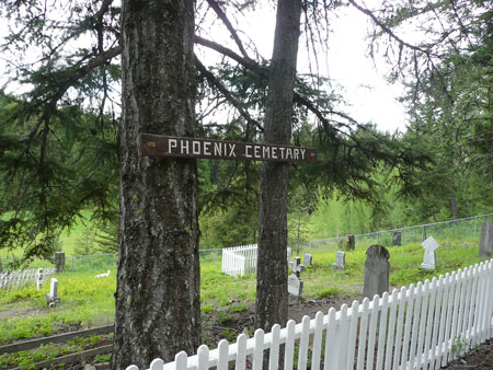
We drove up into the mountains behind Greenwood to Phoenix, where
it and other mining towns once boomed. We stopped at the
Phoenix Cemetery, walking through the graveyard noting most of the
inhabitants were from Wales, Scotland, and England who died in their
20s or 30s. We passed the sign to the Phoenix Ski Area (a mistake we
later learned) and kept driving for 22 extra miles (the better part of
an hour) before the road quit on us! We should have taken the fork to
the
ski area and dropped down to The Crow on the backside of
town. Next time we’ll stop at the visitors center for a map!
“The Crow” continued to be a beautiful drive through
the Selkirks and over two +5,000' passes (Bonanza and Kootenay)
following part of the Trans Canada Trail. We stopped
at The
Borsch Bowl in Grand Forks
for some of their “world famous” beet
soup, then on to Castlegar and Creston, and finally to border crossing
where a young customs agent inspected our refrigerator and officiously
and proudly confiscated our single tomato—holding it like a dead
rat—before we were allowed back
into our country, just a few miles north of Bonners Ferry, Idaho.
BONNERS
FERRY AND THE RETURN HOME
Judy and Vicky were childhood friends for several
years growing up in Bucks County, Pennsylvania. (The crinkled black
and
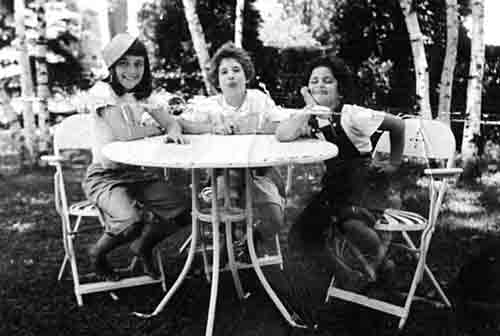
white photo on the right is from 1948. They could not agree on the name
of the third girl with the dog dish on her head.) Though they were
evenutally separated as Vicky moved and Judy stayed in Bucks County,
they didn’t
forget
each other, even though they never corresponded and for most of their
lives didn’t know for sure where the other lived (Judy thought Vicky
had gone to Bonners Ferry in northern Idaho, but couldn’t say for
sure). Or what their married names were.
Some two years ago, Vicky’s father, a very
well-known author in the 1950s and 60s, died and his obituary was in
the New York Times. The obit identified his children and gave their
names. With the help of the internet, Judy found Vicky’s last name and
address (she has no phone, no internet, etc.). So she wrote a letter
and got a
response, and so regular correspondence continued. In planning our trip
to Canada this year, she also got
directions to her house and a welcome invitation.
Vicky and Fred live well outside of Bonners Ferry
at
the end of a road they named themselves. Their house is a fixed up
pre-WW II model with a wood stove in the kitchen and windows above the
sink that take in the panorama of mountains to the east and look out
over their 70 acres of rolling hills that they share with deer, elk,
wild turkeys, bears, wolves, and an occasional moose. Vicky also raises
chickens and is known as the “egg lady” to over a dozen regular
customers. Behind the tall grass in the back forty is a Volkswagen
graveyard, with hundreds of rusting carcasses left from when Fred was a
VW mechanic. He currently owns and operates The Shop, Inc. where he has
designed and manufactures a high tech precision hair clipper blade
sharpener which he designed, manufactures, and sells worldwide. After
years of struggle and changes in their lifestyles, they have created a
quiet, rewarding, and very satisfying life for themselves.
Vicky walked us around the property, and gave us a
tour of her huge garden. Fred showed us how he makes each part of what
is a complex machine of his own design and how his shop is organized to
complete all the steps required to manufacture his machine. We ate
dinner outside by their barbecue, slept in the RV as usual in one
of the quietest sites on our trip, and had fresh eggs for breakfast.
Judy and Vicky played the “Do you remember.....” game for hours, while
Fred and Hughes talked some politics and philosophy. The dogs chased
the wild turkeys off and pestered the chickens that were safe behind
their wire fence. It was a wonderful reunion. The only regret we have
is that since they do not like to travel far from their home, we won’t
likely
be able to return the favor of hosting them at our place.
We spent the next night in Libby, Montana, at the
Two
Bit RV Park ($25 for full hook-ups, lots of grass, and
pleasant hosts). We were so tired that evening we missed the lawn mower
races at the Loggers Days celebration in the local park. Memorable as
that might have been, we were mightily impressed with local artist Tom
Berget’s two rather large eagle sculptures in town. They are
massive
metal sculptures of steel and bronze, and express the majesty of the
birds
in two different poses.
Flea markets often capture our attention, especially
when the weather is warm and sunny and we’re in no hurry. Kalispell was
one of those spots that made us pause. Just a few miles farther down
the road
in Hungry Horse, we sampled the finest ice cream of any kind we’ve
every had, and we want to tell the world. There are, in this part of
the
world, lots of roadside places that sell huckleberry jam, T-shirts, ice
cream cones and shakes, etc. They tend to all look alike, and so we
chose one at random: Willows
Huckland (or Huckleberryland). What luck! They serve up such
superb ice cream
that we defy you to find any better anywhere. It’s on the left side of
the highway as you approach the park entrance at West Glacier. You will
thank us for the recommendation.
The Going-to-the-Sun
Road across Glacier NP was
closed because of heavy snows and avalanches, so we were forced to take
US 2 around the southern flank of the park. We followed the Flathead
River to Essex, an historic railroad town and home of the Isaak Walton Inn (we should
stop in for a meal or snack
sometime). We passed the fabulous Glacier
Park Lodge, one of the great
national park lodges built in 1912-13 by the Great Northern Railway to
attract travelers to the national park. It lacks the majesty of the
Chateau at Lake Louise, but its lobby is one of the finest in the
world.
Looking for a campground for the night was a
challenge. We had hoped to find one in Browning, 12 miles east of
the
park and principle town on the Blackfoot Indian Reservation. It has a
well-known museum that shows off their history and culture.
Unfortunately, the campgrounds we counted on were either out of
business or
way too far out of town. We were able to find two others in town: one
was a joke and
the other way overpriced and didn’t look clean or kept up. So we left
Browning, missing the museum altogether.
We found our place to stay some 40 miles south on US
89 at a rest area near the “town” of Dupuyer
(not shown on all road
maps). There was no sign saying “No Overnight Camping,” the vault
toilets were spotless, the area was surrounded by lush grass, and there
was little traffic. And we were next to a flat National Forest access
road where Judy ran in the morning.
[Note:
Today Dupuyer is a collection of a few dozen
ranching folks, many of whom may well be descendants of followers of
Louis Riel,
the founder of the province of Manitoba who stood up for
the political and cultural rights of the Metis people in Canada. He led
two
rebellions that prompted him to relocate to the US, taking with him
followers who supported his cause. The Red
River Rebellion
of 1869-70
was followed by the Northwest
Rebellion
in 1885 (after his return to
Canada), which led to his capture, arrest, and execution for high
treason. Both rebellions are important footnotes in Canadian history
and Riel is a fascinating historical figure.]
We drove to Great Falls
for some groceries, filled
the tank with some of the cheapest diesel we had seen in several years,
and
went to the visitors center for some suggestions for exploring Great
Falls. We did bicycle a good portion of the extensive bike path along
the
Missouri River to Black Eagle Dam, the site of the former Anaconda
Copper Smelter that stood on the north bank from 1909 until 1980 when
the company shut it down. Its 506-foot smoke stack was the tallest in
the world until 1919 when a taller one (585 feet high) was erected in
Anaconda, Montana. The Great Falls stack was demolished in 1972 because
it was thought to be a hazard, though it had the strength to withstand
two
attempts to bring it down.
We were encouraged to visit the “great falls”
that
gives the town its name and gave Lewis and Clark fits as they had to
portage around the falls on their way up the Missouri during
their 1804-06 expedition. To our surprise the falls are 15 miles out of
town over an absurdly awful road which, though paved, was
like a potholed gravel backcountry road. The falls, in the end, were
not very approachable nor spectacular. We would not go back nor urge
others to visit. In fact, we left Great Falls with mixed feelings: the
biking was great, the falls were a bust. To add another disappointment,
a great dog park was closed for no apparent reason,
though there was a sign that said it would be closed only for the
morning (we were there in the afternoon) for “turf maintenance.”
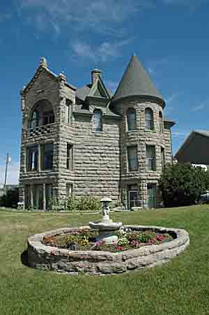
US 89 south took us through the Little Belt
Mountains and the Kings Hill Scenic Byway, as lush as an Irish hillside
with snow-capped peaks on all sides. We slowed through the old mining
town of Neihart,
which boomed in the 1880s, and had periods of
prosperity until WW II when the rail spur was abandoned and the rails
pulled up for scrap metal for the war effort. Though about only 100
folks live there today, the signs of its heydays remain in the
skeletons
of the mills and the tailings that are visible. Neihart is a place to
shich we’d return to dig for fossils and the variety of minerals found
there: gold, galena, sapphires, and amethyst.
We spent the night at the Conestoga
Campground in White
Sulphur Springs, a
pleasant town of historic buildings (some of which have seen much
better days), a hot
mineral spring, and home of all the mosquitoes in Montana. Before
we left
in the morning, we crisscrossed town looking at the historic houses,
only one of which was inviting: “The Castle,” a
restored Victorian
stone house built in 1892 and now the home of the Meagan County
Museum.
We arrived in Livingston
in time for sandwiches in
the shade of the railroad depot park, then walked the streets of this
attractive and vibrant tourist town: an historic train station with a
free museum, well kept buildings downtown that date to the 1890s, the
classy Murray Hotel which is on
the National Registry in spite of its
iconic 1950s-60s name place sign, and three bookstores! They also have
a better than average thrift store on the east side of town where we
scored good paperbacks, women’s clothing, and a box of postcards, all a
rock bottom prices or free.
South of town we took the scenic East River Road
along the Yellowstone River overflowing its banks past Chico Hot
Springs (down a side road) to Gardiner, gateway to Yellowstone NP. Gardiner
clearly exists for the purposes of serving tourists and seems very full
of itself and quick to extort what they can from park visitors. If
campground rates had been even close to
reasonable we’d have stayed and dropped some coins in cute stores. But
no one likes to get gouged, especially by a snotty RV parkkeeper, so we
pushed on into the national park hoping for a campsite without a
reservation.
We had no luck, so we drove out through the east
entrance,
enjoying the park’s scenery and wildlife along the way, and for $5
found a woodsy,
quiet campsite at Three Mile National Forest Campground (no hook-ups,
no trains, no traffic, few mosquitoes, a level site, and clean vault
toilets) on the banks of the swollen North Fork of the Shoshone River,
which rushed by the edge of the campground. We slept well that night.
The next morning we drove on to one of our favorite
towns in Wyoming: Cody,
with its stretch of retail shops along Sheridan
Avenue, the historic (haunted?) Irma
Hotel (named after Buffalo Bill’s daughter)
and its funky shoot-out every evening for the gathered tourists, and
one of three Sierra Trading Post outlet stores in the country which
saved us going
through online shopping. We bought some necessaries at the Sierra
Trading Post store, skipped the Sheridan Avenue enticements, and headed
south for another visit to another of our favorite Wyoming stops:
Thermopolis, home of the
world’s largest mineral hot springs.
The last time we stayed in Thermopolis we camped at
a funky
small campground a short walk from the Hot Springs State Park
(where no
camping is allowed). We looked for it again and learned that it had
been torn down and replaced with a single home. We needed a place
with electricity so we could leave the dogs in the RV with the air
conditioner on (the temperature was 96° at the time) and maybe some
shade. We had three
choices, none perfect: the best of the bunch was a three-mile bike ride
to the hot springs (too far to ride our bikes in the heat we thought).
The worst was only
two miles but right on the highway and without wi-fi for a lot of
money. We settled for the Fountain of Youth RV Park three miles from
the state park but with their own private hot springs on site. Not as
nice as the state park, but they did have shade, full hook-ups. We
soaked the afternoon away, kept the dogs cooled when we were not
walking them, had dinner, soaked again. In the end,
it was a relaxing day. However, we had forgotten that the campground
was
right next to a train track and the trains’ passings, plus rather noisy
neighbors and high winds, made this probably the worst campground for
sleeping of
the entire trip. We won’t return to the Fountain of Youth but will ride
(or drive if necessary) the three miles to the hot springs from the
“good” RV park.
In the morning we stopped at the Hot Springs State
Park for a soak and shower (no charge at the state park) and aimed for
our last night of the trip somewhere in the area of Saratoga (Wyoming)
or the nearby Snow Range. Two events discouraged us from stopping there
and prompted us to make a beeline for home:
•Dark, ominous clouds were in constant view to the
south as we drove in that direction. A good-sized thunderstorm was
brewing and, as we later learned, hit the Snowy Range with full force
and devastating and destructive results; and
•In the middle of Wyoming’s nowhere a gust of wind
that was so strong that our slide-out popped open! Not for long and not
more than about six inches, but is scared the beejeebers out of Lucy
who
was asleep on a bench seat, to say nothing of our surprise
and alarm. We pulled over immediately and saw that the slide had
returned securely to its normal position. We tied a rope across it to
provide some additional security until we got home. When we checked it
carefully at home and found no evidence—that we could see—of any
damage.
[Note:
Another disappointment faced us when we arrived in Shoshoni, just a few
miles south of Thermopolis: The best milk shakes in the country can no
longer be found at the Yellowstone Drug
Store
on Main Street in Shoshoni. It's gone out of business and with it the
heart and soul of Shoshoni—and only reason we know of to stop there.]
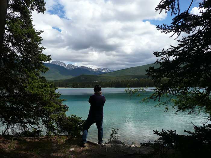
LOOKING BACK
We were been gone 31 days and returned feeling
“vacationed out.” We saw some of the most breathtaking landscapes in
North America: the Canadian Rockies and the lakes and mountains along
the Columbia and Kootenay River Valleys. We saw most of the “big”
animals we had hoped to see: grizzlies, elk, bighorn sheep, mountain
goats, and bison. We struck out on sighting moose and caribou. We saw
no snakes, one very large
bullfrog, thousands of black slugs, and not nearly the
widespread plague of biting insects that we anticipated.
We have seen and poked through and talked with some
folks who live in some intriguing (to
us) old mining towns in both Canada and the US and found their charms
and sensed their historical vitality. We visited towns in which we
think we’d be
comfortable living (Jasper and Nelson, to mention just two). We’ve
learned more about the
importance of trains, especially in the history and development of
western Canada, than we expected. We’ve visited family, old friends,
and new
friends along the way. Bella and Lucy hiked many miles, slept a lot,
ate well, and seemed to enjoy the traveling as much as we did.
We are so very glad we have had the opportunity to
make the trip at last, and we recommend our travels to all who enjoy
the beauty of the outdoors. Western Canada is a beautiful part of the
world, and it’s just across the border.
Someday, if you visit the same areas we think you
will be as awestruck as we were.
