SEDONA, ARIZONA
April 11—22, 2002
 April in Nederland is, as a rule, one of the wettest (i.e., snowiest) months
of the year. If the winter has been particularly cold and snowy and windy, cabin
fever can strike even the toughest of mountain folk, especially those who don’t
ski. Knowing this, we often plan a get-away for the early spring and we set our sites on
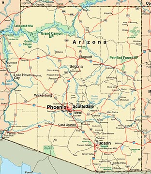
Sedona, Arizona, a small vacation
area between Phoenix and Flagstaff best known for its "red rock" landscapes and New
Age vortexes (or vortices). We knew there was good hiking, excellent mountain
biking, fine scenery, old mining towns, and a great place to relax for a bit. Who knows: maybe
we’d even find a vortex that would speak to us. So we packed clothes for warm dry weather,
put our hiking boots in with the running shoes, put the mountain bikes on the back of the car,
and headed for central Arizona.
ON THE WAY TO MOAB
It’s about a two-day road trip from Nederland, but there
is so much gorgeous country in the 800 miles that we planned to take at least an extra day and
visit some favorite places we’d been to before, and explore some new areas we should have
gone to earlier. We drove quickly across Colorado on I-70, crossed the Utah border, and got off
about half an hour into 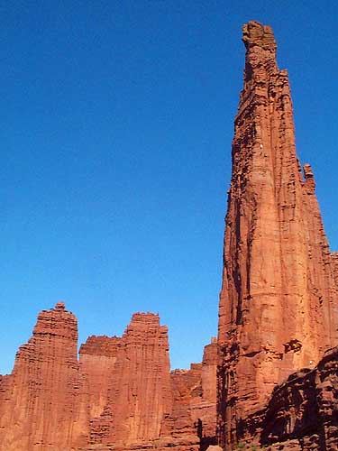 Utah (exit 212) and drove along the Colorado River on State Route
128 headed toward Moab for our first night.
Before we reached Moab, we stopped to bike briefly on a few miles of the Kokopelli Trail. Later,
we parked the car on the highway and biked a few miles up to the base of the Fisher Towers.
This whole length of Route 128, with great biking and quiet camping along the Colorado, is often
bypassed by folks in a hurry to get to Salt Lake City or who want to get to Moab (and Arches
N.P. and Canyonlands N.P., or Lake Powell) on a fast, straight road. This section of narrow and
twisting blacktop takes you past some of the most beautiful "red rock" county in the West. Fisher Towers
is the best known and most striking of the many eroded sandstone monoliths that define this area.
Moab is considered by many, especially those in Moab, as the
mountain bike capital of the country. Certainly it is a recreation destination for thousands
every year. There are miles and miles of trails that run from easy to extreme, and there are at least a half dozen
bike shops and bike tour companies who can rent you a bike, show you where to go, or take you
to the limits of your abilities. If you don’t care for biking, you can also rent jeeps,
hummers, ATVs, go rafting, hiking, and climbing, visit ruggedly beautiful national parks,
and even take helicopter rides over the area.
We stayed the night in Moab, had a delicious Mexican
dinner at Banditos Grill, and found a great bookstore strolling along the main street. The air was warm and dry, just
what we’d hoped for when we left Nederland. Like others who come to Moab for recreation
of all sorts, we’ll be back.
ON THE WAY TO HOLBROOK
The next day we stopped for the first time at
Edge of
Cedars State Park in Blanding, Utah. We knew about the Anasazi ruin there,
but what we really enjoyed was a surprisingly beautiful display of contemporary Mata Ortiz pottery
from Mexico in the museum. Mata Ortiz is the equal of pottery by the Hopis and from the pueblos
of New Mexico, and in many ways part of the same tradition, but taken, we think, to a new level
of fineness and craftsmanship.
We continued south on US 191 to Mexican Water, Chinle, and
stopped in Ganado at the Hubbell Trading
Post, a National Historic Site run by the National Park Service and still doing business
as a traditional trading post. Though we’d been there once before, this time we took
the guided tour to learn about the Hubbell family and the traditions they began as one of the
earliest posts to support native weavers.
 From Ganado we drove just a bit further south to I-40 which paved
over much of historic US 66. It was an hour to our next night’s stay in Holbrook, once an
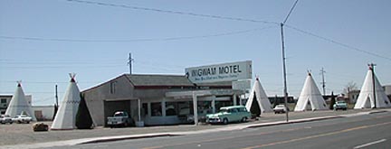
important stop on US 66 that still retains much of the 1950s flavor of that historic highway. Joe
and Aggie’s Cafe and the Wigwam Motel are relics of the 40s and 50s, and are still doing business as
they did when US 66 really was the “Mother
Road.” We stopped in a the Wigwam to consider staying there, but in spite of the nostalgia
which was clearly on sale, the (wigwam) room was cramped and dark--good enough for easterners
of a generation or two ago looking for some phony western experience, but a bit too 1950s for us.
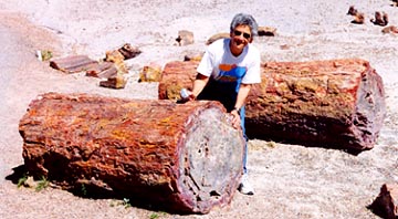 The big draw for us was the nearby
Petrified
Forest National Park and Painted Desert area to the east of town. We’d not been before and
the half day we spent hiking through and around the fallen mineralized trees was an amazing
experience. The temperature was was mild and spring-like, nothing like the heat of the summer
when most tourists come to this area. There are no trees, no shade, and often folks spend
little time really hiking this desolate but stunning desert area. We visited the former Stone Tree House, now
the Painted Desert Inn, built by Herbert David Lore on the north side of the park in 1924. It
housed the CCC in the 1930s and later sold to the Fred Harvey Company who refurbished the
interior with southwest motifs; of particular importance are the murals done by Hopi artist Fred Kabotie. Today
the Inn is a National Historic Landmark a park museum displaying what was incredible luxury to
the few tourists who could afford the finest accommodations of the day.
FINALLY, TO SEDONA
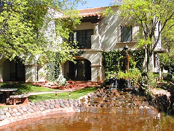 After the Petrified Forest stop and another brief one in Flagstaff for groceries, we drove
the 28 miles down beautiful Oak Creek Canyon from Flagstaff to
Sedona and the
Los Abrigados Resort and Spa,
our destination for the next week. Though we had not seen the resort before, we could not have
selected a nicer place to stay. It features several restaurants, two pools, a comfortable suite
of rooms for us with an adequate kitchen, fitness and spa facilities for Judy’s massages,
tennis and miniature golf (which we didn’t use) and a short walk to fine galleries. Oak
Creek runs right through the property so I could practice fly fishing just a few short steps
from our rooms. More important, however, were the terrific hiking and biking opportunities
within a few miles of Los Abrigados.
The area around Sedona is red sandstone formations with
pinon and juniper vegetation, along with yucca, cactus, sage, and other grasses associated
with high desert areas. Red
Rock State Park seems to surround the town and offers a wide variety
of recreational opportunities, as well as being home to a number of vortexes
that are the destination of new age believers. (A recent study by Northern Arizona University
reported that 64% of visitors to Sedona came “seeking some kind of spiritual experience... Vortex
sites are some of the most visited and impacted sites in the Red Rock Country of Coconino
National Forest.” No wonder, then, that several of our hiking and biking destinations were,
coincidentally, to a vortex where we commingled with individuals or groups meditating.
We hiked the West
Fork Trail, a slot canyon (see photo on right) at the northern 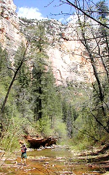 end of Oak Creek Canyon
until we couldn’t go any farther without hiking knee-deep through the creek. Another day
we hiked the Boynton
Canyon Trail on the north side of town, site of several vortex sites. Both of these hikes
are easy to moderate 5 to 6 mile hikes, and both offer spectacular views. With over 60 trails
within the region, we’ll have plenty of new trails to try out on our next visits.
Bicycling in the Sedona area is as popular as
hiking, though you’d never know it from the lack of bicycle lanes and narrow
 shoulders along the roads. To be safe, you need to cart your bike to a trail head
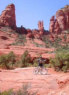
and return to your car when you run out of trail. We especially enjoyed the 15-mile loop
we took from the village of Oak Creek, just south of Sedona, that followed the easy
Bell Rock Pathway north to the Big Park Loop and Little Horse Trails. What
started out as a hard packed two-lane pathway, went through paved neighborhoods, to jeep roads
and finally a fairly challenging rocky single track that was steep enough is some places that
we walked (or flopped) until we came to less challenging stretches. That’s Judy on the
left posing on the edge of Chicken Rock, the beginning of a two-mile stretch of technical,
tough (we thought) single track and the site of Hughes’s headfirst flop into an area
thankfully without snakes, cactus, or yucca. Like our hikes, we had sensational weather: April
temperatures 65° to 70°, clear skies, and light breeze. At the end of each, we returned
to Los Abrigados for rest, a massage, a swim, and even some fishing.
One of the nice things about Sedona is that is is relatively close
to quite a few other interesting spots: the Grand Canyon is within a couple of hours (we didn’t
go). The old mining town of Jerome that sits atop Cleopatra Hill a mile from the Gold King Mine (copper)
was once the territorial capital, and is within an hour’s drive of Sedona. We poked around
the mine camp souvenir shops and had lunch at a place that made the best margarita I’ve
had in years; they would not give me the recipe except to say it was made with Herradura silver!
On the way home we stopped at Tuzigoot National Monument,
Montezuma’s Castle National
Monument, and Montezuma’s Well, all built and inhabited by the 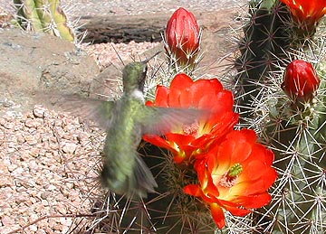 Sinaguan people, contemporaries
of the Anasazi, and each small and interesting in its own way.
I should add that we passed by a desert plant nursery so
attractive and spread out that we turned around to take a closer look. They had too many
varieties of varieties of cactus to count, most of which were in bloom. Judy bought a dozen
specimens that have thrived and re-bloomed here at home.
And did I mention art galleries? There are dozens of sculptors,
painters, photographers and other artists who have there works throughout town. Many are located
in the Tlaquapaque Center, a serene outdoor
collection of shops, small restaurants, and boutiques with something for everyone’s
pocket book. Since it adjoined Los Abrigados where we were staying, we strolled through the
area several evenings, always seeing something new and intriguing.
Any description of Sedona would not be complete without some
mention of the commercial jeep trips through the Red Rock Country. Sedona is particularly well
known for a company that uses only pink
jeeps; they are one of Sedona’s best known “landmarks.” There. I’ve
mentioned them.
GOING HOME
We often return from a road trip like the horse heading
to the barn at the end of the day: fast and direct. From Sedona to Flagstaff to Gallup
to Shiprock and to Farmington the first day. We passed landmarks familiar to us:
Richardson’s Trading
Company in Gallup, where shoppers for kachinas know the quality and prices are good; holy
Shiprock Peak, a 7178'
landmark that can be seen from a hundred miles in all directions across the empty high desert
of the four corners region; north on US 666 along the eastern edge of the Navajo Reservation,
Leaphorn’s and Chee’s highway in Hillerman’s mysteries; Foutz’s Trading Post in Farmington, where we have purchased most of
our rugs.
East of Farmington we entered Colorado by way of Cumbres Pass
(10,022') and La Magna Pass (10,230'). We followed the Cumbres and Toltec Railroad, an historic narrow gauge line that takes
tourists over some spectacular scenery, especially in the fall when the groves of aspen are
gloriously golden. The railroad connects Chama, New Mexico, with Antonito, Colorado, the
southern gateway to the historic San Luis Valley, where the state’s earliest European
settlements were established just following the war with Mexico of 1848. This area is still
home to hardworking farmers and ranchers who have always had to scratch hard for a living from
the earth, a quite different image from the Aspen and Telluride crowd who give our state an
image with superficial glamor and glitz. The roads in this south-central region can be as flat
and straight as any in the midwest, but the peaks of the Sangre de Cristos or the San Juans
are always on the horizon. There’s a quiet beauty of open spaces here, and the mountains
are a majestic as anywhere in the west.
When we arrived in Alamosa we turned east for the interstate
to make a beeline for home. On the way north on I-25 we endured the traffic, the congestion,
the hurry, and the press of people we had escaped the past ten days. But at 70 mph we were not
long going through the craziness and confusion. As we crested the road up from Boulder at the
dam to catch our first glimpse of Nederland and the Indian Peaks, we knew we’d had a great
trip, but this is home—and it always feels good to be back.
 April in Nederland is, as a rule, one of the wettest (i.e., snowiest) months
of the year. If the winter has been particularly cold and snowy and windy, cabin
fever can strike even the toughest of mountain folk, especially those who don’t
ski. Knowing this, we often plan a get-away for the early spring and we set our sites on
Sedona, Arizona, a small vacation
area between Phoenix and Flagstaff best known for its "red rock" landscapes and New
Age vortexes (or vortices). We knew there was good hiking, excellent mountain
biking, fine scenery, old mining towns, and a great place to relax for a bit. Who knows: maybe
we’d even find a vortex that would speak to us. So we packed clothes for warm dry weather,
put our hiking boots in with the running shoes, put the mountain bikes on the back of the car,
and headed for central Arizona.
  Utah (exit 212) and drove along the Colorado River on State Route
128 headed toward Moab for our first night.
 From Ganado we drove just a bit further south to I-40 which paved
over much of historic US 66. It was an hour to our next night’s stay in
  The big draw for us was the nearby
 After the Petrified Forest stop and another brief one in Flagstaff for groceries, we drove
the 28 miles down beautiful
  end of Oak Creek Canyon
until we couldn’t go any farther without hiking knee-deep through the creek. Another day
we hiked the
  shoulders along the roads. To be safe, you need to cart your bike to a trail head
and return to your car when you run out of trail. We especially enjoyed the 15-mile loop
we took from the village of Oak Creek, just south of Sedona, that followed the easy
 Sinaguan people, contemporaries
of the Anasazi, and each small and interesting in its own way.
