SAN JUAN RIVER
June 21–26, 2003
THE MAKINGS OF A RIVER TRIP
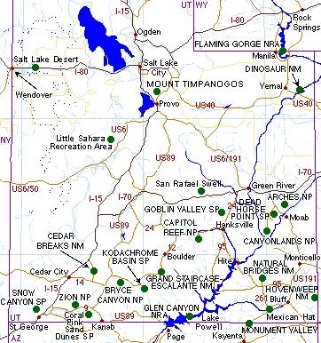 The San Juan River begins its 360-mile journey on the slopes of 13,150' Montezuma Peak
in Colorado’s San Juan Mountains. It is joined by the Piedra and Los Pinos Rivers in the reservoir
behind Navajo Dam in northern New Mexico. It flows southwest out of the dam, gathering strength from the
Animas, the La Plata, the Mancos, and the McElmo Rivers, before carving out a 1,000' twisting gorge
through the Goosenecks in southeastern Utah. The river finally loses its power and identity when it
merges with the Colorado at Lake Powell and dumps its sand behind the Glen Canyon Dam.
The San Juan River begins its 360-mile journey on the slopes of 13,150' Montezuma Peak
in Colorado’s San Juan Mountains. It is joined by the Piedra and Los Pinos Rivers in the reservoir
behind Navajo Dam in northern New Mexico. It flows southwest out of the dam, gathering strength from the
Animas, the La Plata, the Mancos, and the McElmo Rivers, before carving out a 1,000' twisting gorge
through the Goosenecks in southeastern Utah. The river finally loses its power and identity when it
merges with the Colorado at Lake Powell and dumps its sand behind the Glen Canyon Dam.
Fly fishing attracts folks from all over the country to the upper portions
of the river in search of brownies, cutthroats, and rainbows. But it is
rafting through the quiet
and unique scenery of southern Utah that brings others of all ages and levels of experience to
the 87 miles between Bluff and Clay Hills Crossing on an eastern finger of Lake Powell (follow the
blue line from Bluff to Mexican Hat and left to Lake Powell). In addition to scenery and serenity,
one can explore Anasazi ruins, petroglyphs, abandoned roads and mines that each attest to a history
of human contact in one of the most inaccessible regions of the US.
Though we had never rafted this river, Judy and I often have driven through the area,
camped in the Manti-La Sal National
Forest and Valley of the Gods,
visited Monument
Valley, and spent a week house boating and hiking the side canyons of
Lake Powell. However, here was a chance to
share this area with my ten-year-old east coast urban grandson, Griffin. I signed us up for a 5-day
raft trip on the last 60 miles of the river, from Mexican Hat, Utah, to the pull out point at Clay
Hills Crossing. We joined another couple, eight-year-old David from California and his uncle who
lives in nearby Moab, and two guides from Canyonlands Field Institute. In a short five days, Griffin
learned to paddle a ducky solo: he learned to guide himself through light riffles and rapids, to read
the river’s energy and main course, to avoid rocks, sandbars, and eddies, and to struggle against
fierce headwinds; he hiked up trails and roads long ago abandoned by 19th century gold seekers and
ancient hunters; he swam in side canyon pools to cool off from the searing heat of a cloudless sky;
he slept on the ground and in the tent that protected us from blowing sand and thirsty mosquitos.
He knew he was not in Boston.
BUT FIRST.....MOAB AND ARCHES
Griffin had heard of Moab,
Utah, famous for its mountain biking and scenery. It was on our way, so we made it part of the
trip. We drove west on I-70 across Colorado and into Utah, turning off I-70 at the Cisco exit (on the
right side of the map above about where the "70" is to the right of Green River) and following the
Colorado River past Fisher
Towers to Moab on route 128. We crossed the popular
Kokopelli Trail
where thousands of mountain bikers annually make the several
 day back roads journey from near Fruita, Colorado, to Moab. We didn’t mountain bike, but instead took
a whirlwind tour of Arches National
Park, just a short five miles north of Moab.
day back roads journey from near Fruita, Colorado, to Moab. We didn’t mountain bike, but instead took
a whirlwind tour of Arches National
Park, just a short five miles north of Moab.
With an extra day to get to Bluff for our orientation meeting, we stopped for the night
in Moab, took a relaxing swim at our motel, and with several hours of sunlight, drove the full length
of Arches, stopping only long enough to take the short hike to the Delicate Arch overlook. We decided
we should hike out to the arch in the morning before heading south to Bluff, plus see some of the other
arches up close. We returned to Moab for dinner and a stroll down the main street looking in the art
galleries. We both were stunned by the overwhelming beauty of Tom Till’s spectacular photographs
on view in his Tom Till Photo Gallery on Main
Street. We also stopped in the Arches Book
Company bookstore that was planning a Harry Potter Party that evening, beginning at 11:00 p.m.,
an hour before the latest Harry Potter book could be legally sold.
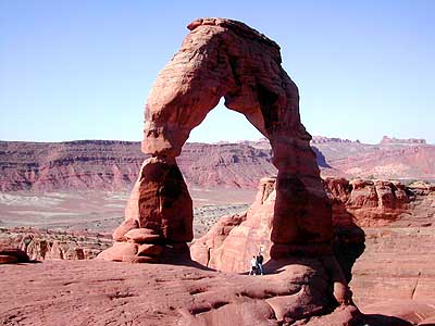
In the morning we were up early for a return to Arches. We hiked out to
Delicate Arch, one of the most
recognized landmarks in all of Utah (it’s featured on one of the state’s three license plates).
It’s an easy mile and a half to the site where those of brave hearts can walk to its base or stand
under the arch itself. (We were brave.) We also walked to Double Arch, North and South Window Arches,
and Turret Arch. It is an impressive place to visit: the winds have sculpted awesome sandstone walls,
hoodoos, and more than 2000 arches in a tiny area in a region of many arches.
BLUFF, UTAH
We left the Moab area for the last leg of our trip, the hundred miles south to Bluff.
On the way we took a bypass to the Needles Section of Canyonlands
National Park, one of the least visited sections of this arid and wild park dominated by the
confluence of the Green and the Colorado Rivers. Along the way we stopped at
Newspaper Rock State Historic
Park to “read” what the Anasazi, the Utes, and modern graffiti
writers left behind. At the campgrounds in the park, we saw just one campsite
in use and fewer than five cars. It’s a very remote experience for those
hikers and backpackers who choose to come here.
We arrived in Bluff in time for a swim and relaxing at the very comfortable
Recapture Lodge.
With few restaurants from which to choose in
 this town of 300, the motel manager recommended the restaurant at the Cow Canyon Trading Post,
a collection of buildings we’d passed coming into town. From the outside the place looked
nearly deserted: an early 1950s Buick sat rusting next to what looked like a former island for
gas pumps. An equally ancient truck was permanently parked on the other side of the property
nearly blocking the front door of the restaurant. It was one of those places most people would
pass by without notice. Thanks to the manager of the Recapture Lodge, we met trading post owner
Lisa Duran and had one of the finest gourmet dinners we never expected in Cow Canyon, Bluff,
or anywhere. What a find!! We’ll be back and plan our trip around dinner there.
this town of 300, the motel manager recommended the restaurant at the Cow Canyon Trading Post,
a collection of buildings we’d passed coming into town. From the outside the place looked
nearly deserted: an early 1950s Buick sat rusting next to what looked like a former island for
gas pumps. An equally ancient truck was permanently parked on the other side of the property
nearly blocking the front door of the restaurant. It was one of those places most people would
pass by without notice. Thanks to the manager of the Recapture Lodge, we met trading post owner
Lisa Duran and had one of the finest gourmet dinners we never expected in Cow Canyon, Bluff,
or anywhere. What a find!! We’ll be back and plan our trip around dinner there.
Karla, the Canyonlands
Field Institute representative, met with us after dinner to check out our gear and lead
us on a walking tour of Bluff whose founding is near mythic in Mormon history. The same group that suffered
a six-month trek across the Colorado River at “the hole-in-the-rock” and crossing
Comb Ridge, founded the town on Brigham Young’s orders in 1880. The settlement lasted
just 4-5 years before the unpredictable San Juan River flooded their attempts to irrigate
and farming. Blanding and Monticello to the north, where farming was a surer possibility,
were settled by those who left Bluff. Today Bluff relies upon tourism, outdoor adventuring,
and art galleries.
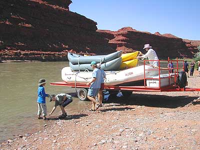
In the morning we rode the van 25 miles south to Mexican Hat where we began our
journey down the San Juan.
SUNDAY, DAY 1
We arrived in Mexican Hat about 10:30. After a very brief safety review
 (drink lots of water, wear sandals all the time, and slather skin with sunscreen) we were
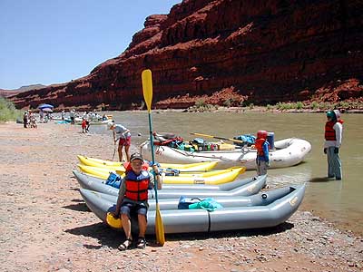
assigned our own duckies (self-baling rubber rafts big enough for two). We packed them with
our dry bags and water bottles, donned helmets and life jackets, and were instructed to keep
behind the equipment raft and in front of who was to be the “sweep” for the day. Not
much instruction (in fact, none as I recall) about how to paddle, maneuver, approach riffles
and rocks, etc.
(drink lots of water, wear sandals all the time, and slather skin with sunscreen) we were
assigned our own duckies (self-baling rubber rafts big enough for two). We packed them with
our dry bags and water bottles, donned helmets and life jackets, and were instructed to keep
behind the equipment raft and in front of who was to be the “sweep” for the day. Not
much instruction (in fact, none as I recall) about how to paddle, maneuver, approach riffles
and rocks, etc.
We put in at Mile 27. Griffin seemed to take to paddling easily, though he did
fall out when the lead raft which he was following got hung up on a rock and he misjudged what
to do and hit a pretty fair hole sideways. But he went back for his paddle and, with some help,
got back in the ducky. End of excitement! He’d been very watchful, accepted some hints
from Grampa, and did quite well for a beginner. We knew there were not many rapids on the San
Juan; Lisa Kearsley’s San Juan River Guide
(Shiva Press, 2002) notes only five between Mexican Hat and Clay Hills Crossing.
We camped at mile 38, over 1,000' below Goosenecks State Park. In spite of Griffin’s spill, we had had lots of
easy drifting, great scenery, and a good campsite. Griffin and David must have thrown a thousand
rocks into and across the river before and after dinner (and at most every stop on the trip). No
tent tonight; we put our sleeping pads and bags behind some tamarisk and slept very well.
MONDAY, DAY 2
 The weather has been stupendous. The sky was a cloudless Utah blue, temperatures
warm to hot and no rain in sight. We did face some pretty fierce head winds in the afternoon
which taxed everyone’s strength at the end of what was a very long day: We combined 20
miles of river with 3-4 miles of hiking.
The weather has been stupendous. The sky was a cloudless Utah blue, temperatures
warm to hot and no rain in sight. We did face some pretty fierce head winds in the afternoon
which taxed everyone’s strength at the end of what was a very long day: We combined 20
miles of river with 3-4 miles of hiking.
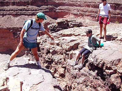
At mile 44 we beached the raft and duckies, put on our hiking shoes, and climbed
the Honaker Trail about two miles up to a river overlook. To get to the edge of the overlook,
we had to cross a four foot crack in the rock that was over one hundred feet down! The trail was
constructed by gold seeker Augustus Honaker in 1894: a treacherous 1,200-foot path “not
fit for stock, and supplies had to be lowered by rope near the bottom.” Honaker found
very little gold in the river, just enough to make a ring for his wife. The view from the
overlook looking down on the river was worth the short hike and the steep trail.
Griffin continued to do well on his own. He took on his first bona fide
rapid—Ross Rapid—just past mile 52. He could have chosen not to, but wanted to do
it on his own. It was probably a class II, though with low water (less than 500 fps) it may
have been riskier. We scouted it for several minutes before picking our route. That sort of
thing heightens the excitement of running the rapid itself. While scouting the rapid we learned
about WORMS: Water (where it’s running smoothest), Obstacles (e.g., rocks, holes), Route
(decide where you’re going), Markers (a tree or rock that near an obstacle or where you
want to begin your route), and Scenario (i.e., what to do if things don’t go as planned).
We spent much more time today than planned on the river. After Ross Rapid,
(Mile 52.5) we took an hour or two looking for a camp site. The one our guide had in mind
was taken and we finally came to John’s Canyon at Mile 58.5. We were dead tired; we fixed
and ate dinner just before dark and then went to bed.
Observations halfway into the trip:
1. The food is good, though certainly not fancy. CFI provides plenty of snacks,
fruit, and water. There are morning and afternoon stops in addition to lunch. No one could
ever complain about being hungry.
2. For an Elderhostel sponsored trip, we’ve had precious little “educational”
focus. While the guides respond to questions, there seems little planned that would enrich
our understanding of the geology or 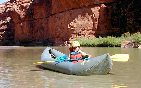 history of the area. The boys did learn two quick,
keep ’em busy fun games, but we’ve both forgotten them. The guide-intern got the
best education about rowing a large raft and reading a river.
history of the area. The boys did learn two quick,
keep ’em busy fun games, but we’ve both forgotten them. The guide-intern got the
best education about rowing a large raft and reading a river.
3. Insects have been not a problem (so far). We did sleep near the ants this
evening (again, no tent) and fell asleep to the sound of locusts. A few pesky flies appeared
this evening, but we slept through them.
4. Griffin has small blisters on his feet from his Tevas. Wearing socks and
loosening the straps has helped a great deal, but the general advice from experienced folks
is that Chacos are superior and more desirable.
5. Spare gear: an extra pair of dark glasses should be required. We also should
have brought gloves—not for warmth but to reduce the blisters both Griffin and I have
on our hands.
TUESDAY, DAY 3
What a day! Who’d have thought on the same day (1) Griffin would get flipped
out of his ducky and wind up with a stone in his knee, and (2) the guide would get the equipment
raft seriously hung up on 2-3 large rocks in the middle of Government Rapid?
An hour out of camp the wind began to gust mightily, usually straight in our faces,
but occasionally shifting to one side or the other when least expected. We estimated the gusts
at +35 mph. Griffin approached the second “riffle” (a class I rapid?) of the day;
he went straight in, nose first, but the wind gusted and shifted just enough to catch the side
of his ducky and knock him sideways. He flipped before he could react and wound up underneath
the ducky (“What did you do then?” I asked. “Got out from underneath,”
he said, stating the obvious.) He hit his knees on some rocks while righting himself in the
moving water. When he surfaced and saw where he was, he retrieved his paddle and waded to
shore. One of the guides brought 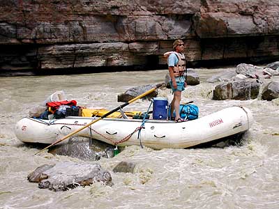 his ducky to him. When I got to him he still had
a small pebble embedded in his right knee which I promptly removed. He was a bit shaken,
shivering, soaked, and maybe a bit scared. He said he was worried about his knees, both of
which were bleeding a tiny bit (and hurt). Some Motrin, a dry jacket, and encouragement got
him back in the ducky and he successfully navigated the next riffle a half mile away.
his ducky to him. When I got to him he still had
a small pebble embedded in his right knee which I promptly removed. He was a bit shaken,
shivering, soaked, and maybe a bit scared. He said he was worried about his knees, both of
which were bleeding a tiny bit (and hurt). Some Motrin, a dry jacket, and encouragement got
him back in the ducky and he successfully navigated the next riffle a half mile away.
However, he was truly chilled and somewhat exhausted from fighting the head winds,
so we paddled together all the way to Government Rapid, the “big” one, a rapid that
looked especially tricky at low water. We scouted this short rocky rapid that may have been
a class III (maybe IV?). The guide decided he’d take the equipment raft over by himself
first so that we could watch and those who wanted to run it solo could choose our routes in
the duckies based upon what happened to him.
But he didn’t make it. Like running any rapid, things unexpected can happen,
and quickly. He got wedged sideways in the middle straddling three big rocks. He was truly
stuck. He pushed with an oar, he jumped up and down on the stern, but he was seriously hung
up. Worse, he was taking in water to the point that he sliced the bottom of the raft making
it suddenly a self-baling raft. After much head scratching, we decided to portage the duckies
around the rapid and began unloading the raft. More than an hour later we had ferried, by ropes
and pulleys, several hundred pounds off the raft. Thankfully, three members of a group coming
behind us were able to pull the raft off the rocks and it floated down to where we’d
beached the duckies and carried the unloaded gear. In all, we were 2-3 hours there on what
was to be an early put-in, leisurely day.
It was late by the time we got to our reserved campsite at Mile 66 (Slickhorn
Canyon). The wind was still howling in our faces, and the sand in camp covered everything. Griffin
had the good sense to suggest using the tent which we put up in spite of the wind. We were
very comfortable and snugly protected as we relaxed before dinner.
Griffin’s knees got a lot better. The hole where the pebble was still
 showed—his badge of courage! Our blisters are obvious and his Tevas have stopped rubbing
thanks to wearing socks, though the sides of his big and little toes are red and raw. No
sunburn on either of us.
showed—his badge of courage! Our blisters are obvious and his Tevas have stopped rubbing
thanks to wearing socks, though the sides of his big and little toes are red and raw. No
sunburn on either of us.
WEDNESDAY, DAY 4
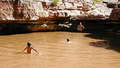
We began the day with a short hike up Slickhorn Canyon. There were several
good-sized pools, one deep enough for swimming and jumping into. Even in the morning it was
warm enough to enjoy the cool water.
Slickhorn Rapid, which the guide book shows just opposite our camp, was a
non-event. It was as though the book was mistaken or the low water made it disappear. We therefore
faced a day as quiet as yesterday was eventful. The river at this point and for the rest of
the trip has succumbed to the “Lake Powell Effect:” the lake waters have forced the
river to drain rather than flow. Sand deposits have built up bars causing us to tack from one
side of the river to the other as we made our way downstream. Sometimes it was so shallow that
we had to get out and push the duckies (and the raft) to a deeper channel. Our progress was slow.
Griffin paddled with me in the morning. We listened to the canyon wrens, saw cliff
swallows, a great blue heron, a mule deer, ravens, Canada geese, and a group of what were either
quail or grouse. It was quiet and relaxing. Griffin could have made it solo, but I enjoyed the
chance to chat and point out things he might have missed if he were concentrating on paddling.
On the other hand, the winds challenged us and he seemed to be suffering a bit from sunburn
on his shins. He walked around camp at lunch and dinner like an old man with achy knees.
We pulled into Steer Gulch Camp (Mile 77.5) which we promptly renamed Mosquito
Gulch. They were vicious and bloodthirsty. We sprayed ourselves, but they ate right through
the Deet. Only the bats looked forward to dusk when the two species did battle. I hope the
bats won. We were able to get the tent up which assured us a pleasant sleep.
After dinner, we built a campfire, ate some s’mores and shared poetry and
readings with each other. One of our fellow rafters (the uncle 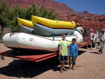 from Moab)
read an edited selection from Edward Abbey’s Down the
River, a collection of short stories of Abbey’s river travels. The
account of Abbey’s rafting the San Juan perfectly describes our trip and provides
unique Abbey insights on the river and the human history of the area. Griffin’s poem,
“River/Roads” by Canadian Michael Crummy, contrasted highways and rivers. The poet
spoke of “the earnestness of pavement (and) its insistence on leading you somewhere,”
whereas “a river is less opinionated, less predictable.” It was a good choice.
from Moab)
read an edited selection from Edward Abbey’s Down the
River, a collection of short stories of Abbey’s river travels. The
account of Abbey’s rafting the San Juan perfectly describes our trip and provides
unique Abbey insights on the river and the human history of the area. Griffin’s poem,
“River/Roads” by Canadian Michael Crummy, contrasted highways and rivers. The poet
spoke of “the earnestness of pavement (and) its insistence on leading you somewhere,”
whereas “a river is less opinionated, less predictable.” It was a good choice.
THURSDAY, DAY 5
We were scheduled for a 2:00 pm take-out at Clay Hills Crossing, but we decided
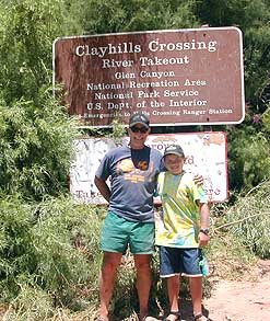 that since we were so close, we easily could be there by noon, an hour
before the next large group was scheduled for take out. So we were up earlier than usual,
ate and packed efficiently, and were on our way by 8:30. Only six miles to the take-out and
the river was calm and obliging. We arrived before noon after a gentle, breezeless morning. We
unloaded the raft and manhandled it onto the waiting trailer and strapped the duckies on top
of that. After a quick lunch, we took our group photos, piled into the van with the trailer
behind and headed for the pavement of state highway 276. We carefully worked our way down about
30 hard miles of rough dirt and gravel across a typically desolate high desert landscape. The
pavement felt good and we were back in Bluff by about 3:00. Plenty of time to make Moab before
dark, have a much needed shower and a meal where we could sit on a chair and eat from a table.
that since we were so close, we easily could be there by noon, an hour
before the next large group was scheduled for take out. So we were up earlier than usual,
ate and packed efficiently, and were on our way by 8:30. Only six miles to the take-out and
the river was calm and obliging. We arrived before noon after a gentle, breezeless morning. We
unloaded the raft and manhandled it onto the waiting trailer and strapped the duckies on top
of that. After a quick lunch, we took our group photos, piled into the van with the trailer
behind and headed for the pavement of state highway 276. We carefully worked our way down about
30 hard miles of rough dirt and gravel across a typically desolate high desert landscape. The
pavement felt good and we were back in Bluff by about 3:00. Plenty of time to make Moab before
dark, have a much needed shower and a meal where we could sit on a chair and eat from a table.
FOOTNOTE ON THE WAY HOME
We returned the way we came: Moab to the Cisco exit on I-70 and due east
to the Nederland exit. However, we made a short stop in Fruita (Colorado), home of
Mike the Headless
Chicken and to leave a note for our former neighbors who moved there a few years ago. We
didn’t see Mike the Headless Chicken, but we did see the statue of him near the park, talked
with folks who remember him, met the city manager who was at the courthouse when we went to buy a
Mike the Headless Chicken Festival
T-shirt. They think our Frozen
Dead Guy Days is strange. Come on, Fruita. You celebrate a headless chicken!!
By the time we returned home to Nederland, we thought another shower was in
order. Griffin’s sunburn had moved to a strip of red on both biceps, his toes were still
a bit raw, and both of us had three blisters on our hands. Griffin packed for his flight the
next day to Massachusetts where he no doubt will show the dent in his right knee from the
pebble briefly embedded and enjoy some bragging rights among his friends for having taken on
the San Juan River solo!
We both enjoyed a wonderful experience together and alone in our own thoughts as we floated down the San Juan. We both were reminded that there are always new places to discover and experience. And a river trip may be the best way to learn to take life as it comes to you.
