SWITZERLAND
June 14-27, 2000
THE BIG PICTURE
We arrived in Zurich
about three hours early for our connection to Appenzell, so we had some
time to "see" Switzerland's largest city. We took a bus an hour or so east
to St. Gallen
and then south about half an hour to Appenzell
where we stayed to hike this area. Six days later we traveled south and
west to Engelberg for another week of
alpine hiking. Our return flight was out of Zurich.
ROMANTIC IMAGES
From the old and pleasantly situated
village of Mayenfeld, a footpath winds through green and shady meadows to
the foot of the mountains, which on this side look down from their stern
and lofty heights upon the valley below. The land grows gradually wilder
as the path ascends, and the climber has not gone far before he begins to
inhale the fragrance of the short grass and sturdy mountain-plants, for
the way is steep and leads directly up to the summits above.
So begins Johanna Spyri's 1880 (1881?) classic,
"Heidi."
Throughout the story, the images she paints of her 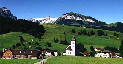 native
Swiss Alps are strong and have lured travelers from all over the world
to enjoy the beauty of the alpine scenery. Many places in our country have
built upon the romantic imagery of Switzerland by comparing local settings
with that area; in Colorado, for example, the town of
Ouray
in the San Juan Mountains advertises itself as the "Switzerland of America,"
and they are not far off. Here in Nederland, we are less than five miles
from the famous "Switzerland Trail," a 19th century railroad that once
ran from Boulder west to the mining areas in the front range and is now
a scenic area for mountain bikers.
native
Swiss Alps are strong and have lured travelers from all over the world
to enjoy the beauty of the alpine scenery. Many places in our country have
built upon the romantic imagery of Switzerland by comparing local settings
with that area; in Colorado, for example, the town of
Ouray
in the San Juan Mountains advertises itself as the "Switzerland of America,"
and they are not far off. Here in Nederland, we are less than five miles
from the famous "Switzerland Trail," a 19th century railroad that once
ran from Boulder west to the mining areas in the front range and is now
a scenic area for mountain bikers.
So it was with the allure of green meadows and alpine huts, peaks both
forested and snow-covered, rural villages (like Brulisau pictured here)
and medieval cities, cows and goats and cheese, and a network of trails
to explore that we joined this Elderhostel hiking trip. We were not
disappointed. Along with twenty-three other walkers and hikers from all
over the USA, we marveled at the charm of the countryside and the treasures
we found in the cities we explored during our short visit.
SOME HISTORICAL NOTES
1. We've often wondered why the Swiss cars had a "CH" label on them next
to the license plates. The Dutch have "NL" for Netherlands, "F" is for
France, and so forth. What does "CH" stand for?
Confoederatio
Helvetica--Helvetia being the tribe of Celts who were living
there over 2000 years ago. The Celts left their imprint almost everywhere in
Europe, including Switzerland (e.g., "alp" is the Celtic word for "mountain").
2. Rome failed to conquer the region, but the Germanic Altemanni tribe
from the north settled the area in the 5th century. The territory was united
under the 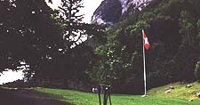 Holy Roman Empire
in 1032. Modern Switzerland grew out of a confederation established in 1291 by
three small city-states--Uri, Schwyz, and Unterwalden--who
declared their independence from Austrian rule. This historic moment took
place at Rutli Meadows, "The Cradle of Switzerland," a modest site of such
national importance that sometime during their school years, students are
usually brought to this beautiful area above the shore of the Vierwaldstattersee
(Lake Lucerne). By 1815, this confederation grew into the modern boundaries of
Switzerland as other city-states joined.
Holy Roman Empire
in 1032. Modern Switzerland grew out of a confederation established in 1291 by
three small city-states--Uri, Schwyz, and Unterwalden--who
declared their independence from Austrian rule. This historic moment took
place at Rutli Meadows, "The Cradle of Switzerland," a modest site of such
national importance that sometime during their school years, students are
usually brought to this beautiful area above the shore of the Vierwaldstattersee
(Lake Lucerne). By 1815, this confederation grew into the modern boundaries of
Switzerland as other city-states joined.
3. Modern Switzerland avoids political alliances; they're not, for example,
members of the UN, NATO, or the European Union, although there is current
pressure to join the EU. The country is often referred to as "neutral,"
though the history of Switzerland during WW II, which many Swiss are now
recognizing publicly, was anything but "neutral." More power is held by
cantons to govern their local affairs than is granted to the central
government. There are 26 cantons
(states), six of which are "half cantons" that were formed when three cantons
(Appenzell, Unterwalden and Basel) split in two: e.g., Appenzell split
into Appenzell Ausserrhoden and Appenzell Innerrhoden, part for the Catholics,
part for Protestants.
4. Citizens of the canton of Appenzell Innerrhoden hold their annual
"Landsgemeinde"
in the town square. Voters (women were granted voting privileges only within
the last ten years) raise their hands in public to vote for or against
political candidates, proposed ordinances, applicants for Swiss citizenship,
and other issues. Hands are counted and the outcome is known immediately.
5. There are four national languages recognized in Switzerland: German,
French, Italian, and
Romansch (spoken by about 1% of the people living in southeast areas).
6. The story of William Tell stands foursquare alongside the story of
George Washington cutting down (or as
Parson Weems
wrote, "barked") the cherry tree.
THE MOUNTAINS
Switzerland is comprised of three regions: The Jura in the north
makes up the French and German alpine region; The Midlands, an area
of flat and rolling countryside that makes up 30% of the land and where
most of the people live; and The Alps, which comprises the 60% of
the land across the southern part of the country and home of our two hiking
destinations.
HIKING IN APPENZELL
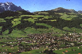
Appenzell is a canton
, a dog,
and a postcard pretty rural village of about
twenty randomly placed blocks nestled at the foot of Mt. Santis
(elevation about 8100') and the Alpstein region. Just a few miles to
the east is the Rhine River and, across it, the Austrian Alps. While
there is some skiing around Appenzell during the winter, this village
of 4,000 and the area are best known and well suited to hiking, as well
as to raising
Brown Swiss cows and making Appenzell cheese.
(Note:
Albert Manser's 1987 picture book, "Little
Albert," uses beautiful folk art paintings
to faithfully depict a year in the life of a typical Appenzeller family.
His work, along with other folk artists, was on display and for sale in
several stores in Appenzell as well as the museum shop. It's also likely
found in your public library.)
The Hotel Lowen (below) is ideally located in the heart of this small town,
across from shops and restaurants, close to the train station, two blocks
from a river path perfect for morning runs, near the magnificent St. Mauritius
Church with its garden-like cemetery where folks are permitted a burial
spot for twenty-five years only; after that their bones are 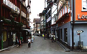 exhumed
and buried in the church crypt, thereby making room for another year of
parish deaths). The storefronts that face the narrow streets have hand
painted facades and shutters. (This "tradition" of decorated store fronts
goes back only to the 1930s and was started by in itinerant painter looking
for work.) The village is maintained for window shopping and tourists who
come by the bus loads during the day and usually leave before
dinner.
exhumed
and buried in the church crypt, thereby making room for another year of
parish deaths). The storefronts that face the narrow streets have hand
painted facades and shutters. (This "tradition" of decorated store fronts
goes back only to the 1930s and was started by in itinerant painter looking
for work.) The village is maintained for window shopping and tourists who
come by the bus loads during the day and usually leave before
dinner.
The elevation of Appenzell is about 2,700' and our hikes took us no higher
than 6,000'. The terrain ranges from flat along the rivers to moderate
grades in the mountains. We used trains, cable cars, and buses to reach
our trail heads. We measured hiking distances in hours rather than miles,
and averaged three to five hours of actual hiking time each day. Our hikes
in the Appenzell area took us to:
- Hoher Hirschberg.
We took a short train ride north to Gais and walked an hour or so up
the gentle hills to a gasthaus ("guest house") for good barley soup to
go with the sack lunch prepared by the hotel. The walk down to Appenzell
was a gentle stroll, perhaps meant to acclimatize folks who live closer
to sea level and to help sort out the group into walkers and hikers for
the rest of the trip.
- Kronberg.
After a half-hour run at sun up, we
 took the train to Jakobsbad and a gondola
to the top of Kronberg (elevation about 5500') with great views of the
whole region. The walking group took the gondola back down and walked along
the river back to Appenzell. We joined the small group of hikers for the
often steep downhill hike to the bottom before returning to Appenzell by
a gentle footpath. On the way down the mountain we passed through the alpine
summer grazing pastures for the Brown Swiss cows, stopped briefly at a small shrine
(shown at the right), and, just a short way beyond, bought cheese from a
woman who makes both cheese (which she sells to hikers) and butter (which
she sells to restaurants in town) in a two-room hut on the mountainside
where she lives during the summer.
took the train to Jakobsbad and a gondola
to the top of Kronberg (elevation about 5500') with great views of the
whole region. The walking group took the gondola back down and walked along
the river back to Appenzell. We joined the small group of hikers for the
often steep downhill hike to the bottom before returning to Appenzell by
a gentle footpath. On the way down the mountain we passed through the alpine
summer grazing pastures for the Brown Swiss cows, stopped briefly at a small shrine
(shown at the right), and, just a short way beyond, bought cheese from a
woman who makes both cheese (which she sells to hikers) and butter (which
she sells to restaurants in town) in a two-room hut on the mountainside
where she lives during the summer.
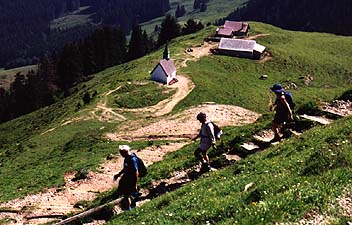
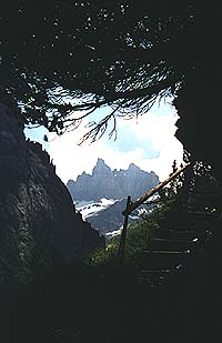
- Hoher Kasten.
We took
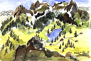 the train to Weissbad and a bus to Brulisau (see the photo at the
beginning of this web page) to begin our hike to the top. This felt like
our first "real" mountain hike: a 3000' gain in three hours to the gasthaus
at 5500' where the views were expansive. To the north we could just make out
Lake Constance; to the east was the Rhine, Austria and Liechtenstein; and to
the south and west were the alps and several alpine lakes including Samtisersee
which fellow hiker, Philip Bennet, captured beautifully in a small watercolor
that he generously sent us as a remembrance of the trip. After a sack lunch
and a bottle of Appenzeller
Bier, we took the gondola back to Brulisau and walked the rest of the
way back to Appenzell. We hiked and walked about 12 miles today.
the train to Weissbad and a bus to Brulisau (see the photo at the
beginning of this web page) to begin our hike to the top. This felt like
our first "real" mountain hike: a 3000' gain in three hours to the gasthaus
at 5500' where the views were expansive. To the north we could just make out
Lake Constance; to the east was the Rhine, Austria and Liechtenstein; and to
the south and west were the alps and several alpine lakes including Samtisersee
which fellow hiker, Philip Bennet, captured beautifully in a small watercolor
that he generously sent us as a remembrance of the trip. After a sack lunch
and a bottle of Appenzeller
Bier, we took the gondola back to Brulisau and walked the rest of the
way back to Appenzell. We hiked and walked about 12 miles today.
- Ebenalp and Schafler.
Our last hike
 from Appenzell was spectacular, not for the altitude (we only
climbed to 6200') but for all we saw along the way. We took the train to
Wasserauen and a cable car up to Ebenalp (5300'). From that drop off point
we hiked through the
Wildkirchli Caves (a short tunnel that leads to a small shrine/chapel)
and out along a narrow path up carved out of the rock face to a gasthaus
that clings to the side of the mountain. It is a spectacular setting! We
marveled at what daring and effort it must have taken to build the
restaurant/hotel this spot. After a brief stop, we continued hiking up to
the top of Schafler (the upper right-hand green peak) for lunch and then
hiked back down to the cable car at Ebenalp where, among the Brown Swiss
cows grazing in the pasture, we watched a dozen folks leap off the side of
the mountain on hang gliders to soar for miles over the valley, landing as
close to Wasserauen as possible for their quick return up the mountain to
Ebenalp by cable car and another jump.
from Appenzell was spectacular, not for the altitude (we only
climbed to 6200') but for all we saw along the way. We took the train to
Wasserauen and a cable car up to Ebenalp (5300'). From that drop off point
we hiked through the
Wildkirchli Caves (a short tunnel that leads to a small shrine/chapel)
and out along a narrow path up carved out of the rock face to a gasthaus
that clings to the side of the mountain. It is a spectacular setting! We
marveled at what daring and effort it must have taken to build the
restaurant/hotel this spot. After a brief stop, we continued hiking up to
the top of Schafler (the upper right-hand green peak) for lunch and then
hiked back down to the cable car at Ebenalp where, among the Brown Swiss
cows grazing in the pasture, we watched a dozen folks leap off the side of
the mountain on hang gliders to soar for miles over the valley, landing as
close to Wasserauen as possible for their quick return up the mountain to
Ebenalp by cable car and another jump.
HIKING IN ENGELBERG
We left Appenzell for Engelberg, stopping at the medieval castle of Werdenberg,
above the modern village of Grabs. The castle, overlooking the Rhine, was
built about 1230-40 C.E. Major restoration was completed in the 19th century
by new owners and eventually donated in 1956 to the Canton of St. Gall(en)
and made open to the public. We passed through Liechtenstein
(more banks than churches) and on to 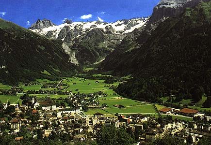 Engelberg (elevation 3400') situated
about an hour south of Lucerne by train. (Note: Engelberg means angel [engel]
mountain [berg] and refers to a vision by an early monk who, casting about for
a place to settle, saw an angel on a mountain and decided to stay.)
Engelberg (elevation 3400') situated
about an hour south of Lucerne by train. (Note: Engelberg means angel [engel]
mountain [berg] and refers to a vision by an early monk who, casting about for
a place to settle, saw an angel on a mountain and decided to stay.)
We settled in to our rooms at the once grand Hotel Hess (it will be torn down
this fall), just a short stroll to the heart of this picturesque ski village
at the foot of
Mt. Titlis (10,000'). The setting reminded us a great deal of Telluride,
Aspen, Ouray and other Colorado ski towns: a narrow river valley, steep
hillsides, snow on the peaks, with a small town stretching along the valley
where the land is flat.
In addition to the hiking in Engelberg, we were fortunate to be in town
for two major events. There was a national dressage competition in the
park in town where we were able to watch some of the horses and riders
practice their programs in the afternoon and evening. In addition, the
day we toured Engelberg's magnificent Benedictine abbey and monastery,
built in 1120 C.E. was on the day of the town's Corpus Christi celebration.
After our tour of the monastery and abbey led by the curator, we hurried
back to the park where townsfolk were gathering to parade to the church:
priests, nuns, old people, families, and lots of well dressed children
in procession to the church for services. We followed and stayed for much
of the service to enjoy the huge organ which was capable of filling the
church with bone-rattling sound. Alas, the organist was timid.
The kind and extent of our hikes in Engelberg was dependent upon the weather.
Unlike the warm sunny days in Appenzell, the mountains surrounding Engelberg
were often clouded over, the skies were gray, and we had drizzle and even
snow and white-out conditions one day. Despite it all, we had some fine hiking.
- Hess Family Alp Hut.
Genny Hess, the owner of the Hotel Hess
 and an Elderhostel guide during our
stay, led us up the Aa River to his family's hut on the side of the base of
Titlis above Herrenruti and across from Alpenrosli. After a steep climb in
spots and crossing several snow melt streams, we ate our sack lunch on the
front deck of the cabin. We returned to Engelberg through woods and fields
with a stop at Dellenstein, a restored house reputed to be the oldest in the
town. It was built in the late 15th century and lovingly restored by its
current owners who retained the low ceilings, ceramic wood stove, old piano,
and restored the fabulous huge cupboard built (and dated) in 1790 that takes
up an entire 15'-20' wall. The owner served us pie, told us about the history
of the house, and on our last night in town, showed up as the singer (with her
husband and two other musicians) for some music and dancing at the hotel.
and an Elderhostel guide during our
stay, led us up the Aa River to his family's hut on the side of the base of
Titlis above Herrenruti and across from Alpenrosli. After a steep climb in
spots and crossing several snow melt streams, we ate our sack lunch on the
front deck of the cabin. We returned to Engelberg through woods and fields
with a stop at Dellenstein, a restored house reputed to be the oldest in the
town. It was built in the late 15th century and lovingly restored by its
current owners who retained the low ceilings, ceramic wood stove, old piano,
and restored the fabulous huge cupboard built (and dated) in 1790 that takes
up an entire 15'-20' wall. The owner served us pie, told us about the history
of the house, and on our last night in town, showed up as the singer (with her
husband and two other musicians) for some music and dancing at the hotel.
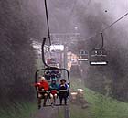
- Ristis-Brunni.
We took a cable car and a chair lift above the town through the clouds for
a wildflower hike. Our guide, a forestry expert named Sapp, knew every plant
along the way in both English and Swiss-German ("Do you also wish the
scientific names?"). It would have been a glorious hike had the cloud settled
higher up the mountain and the weather more conducive to
strolling the hillside. Though we hiked for about two hours, we agreed to
cut short our walk for more time in town.
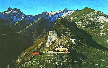
- Mt. Titlis.
 This was to have been the jewel of hikes on our trip, but poor weather prevented
what would have been a terrific hiking experience: up to the 10,000' peak by a
series of cable cars, including "the world's only revolving cable car;" a tour
of the "Glacier Grotto;" followed by a hike to the peak itself and a steep descent
to town with views that would take our breath away. Instead, we ascended through
dense clouds to the building at the top, walked through the Glacier Grotto and
outside where there was a snow-cloud white-out that made any hiking quite
dangerous for lack of any visibility. So we took the obligatory snapshots and
rode the cable cars down to the edge of the cloud and returned by a gentle path
to town. The weather gods were against us that day.
This was to have been the jewel of hikes on our trip, but poor weather prevented
what would have been a terrific hiking experience: up to the 10,000' peak by a
series of cable cars, including "the world's only revolving cable car;" a tour
of the "Glacier Grotto;" followed by a hike to the peak itself and a steep descent
to town with views that would take our breath away. Instead, we ascended through
dense clouds to the building at the top, walked through the Glacier Grotto and
outside where there was a snow-cloud white-out that made any hiking quite
dangerous for lack of any visibility. So we took the obligatory snapshots and
rode the cable cars down to the edge of the cloud and returned by a gentle path
to town. The weather gods were against us that day.
THE CITIES
Not all of our hiking was in the mountains. We engaged in some serious urban
hiking as well. We enjoyed three walking tours (guided) during our two weeks:
St. Gallen
, just north of Appenzell;
Lucerne, called "the most picturesque town in Switzerland," and it
certainly might be; and Rutli Meadows (not really urban, nor did it
involve much hiking).
St. Gallen ("St. Gall" on Swiss maps)
We became aware once again of the Celtic heritage in Switzerland. The name
of St. Gall must certainly have come from the 7th century monk, Gallus,
a follower of St. Columbanus, who arrived in the Lake Constance area around
612 C.E. with books, both 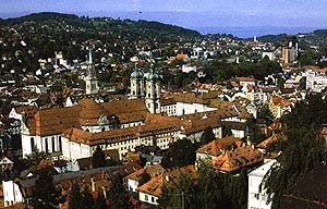 liturgical and biblical. A scriptorium was built and
monks from the area took up the art of copying books. A monastery,
founded in the next century by the Benedictines, became the foundation
for the remarkable Abbey
Library of Saint Gall that we toured. In it we saw hundreds of handwritten
and illuminated manuscripts preserved for public viewing. The interior
of the library is equally magnificent with wood inlays, paintings, and
frescos in ornate Baroque designs. The abbey is a Baroque-Roccoco structure
with a great pipe organ and, like all the churches we visited, with clear
windows to allow for plenty of sunlight.
liturgical and biblical. A scriptorium was built and
monks from the area took up the art of copying books. A monastery,
founded in the next century by the Benedictines, became the foundation
for the remarkable Abbey
Library of Saint Gall that we toured. In it we saw hundreds of handwritten
and illuminated manuscripts preserved for public viewing. The interior
of the library is equally magnificent with wood inlays, paintings, and
frescos in ornate Baroque designs. The abbey is a Baroque-Roccoco structure
with a great pipe organ and, like all the churches we visited, with clear
windows to allow for plenty of sunlight.
The monastery and abbey are in the heart of the old part of the city: narrow
winding streets where the shops and apartments seem to lean out toward
each other in a canopy of stucco, brick, and timbers. Not only is St. Gallen
a university town, but was a linen/embroidery center at the turn of the
last century which gave the town its wealth. We had coffee and pastries
at the Pelikan, a small cafe in the old town where, our waiter proudly
informed us, "Your Mrs. Clinton sat right over there at that table" during
a visit sometime in the past eight years.
Lucerne ("Luzern" on Swiss maps)
Lucerne is a wonderful city for roaming, walking, looking, sitting, and taking
pictures. Once we left the main train station and the new and controversial
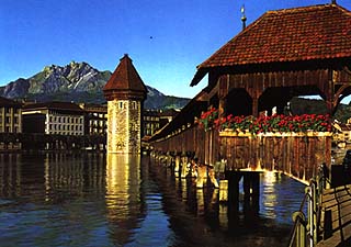 modern concert and convention building across the street, we were back into
the Middle Ages (albeit with car traffic). Among the sights we thought worth
seeing are:
modern concert and convention building across the street, we were back into
the Middle Ages (albeit with car traffic). Among the sights we thought worth
seeing are:
- The Kapellbrucke (Chapel Bridge), claimed as the world's oldest wooden bridge,
was built in 1333. Within the bridge's passageway, there are 120 captioned triangular
paintings in the rafter areas from the early 1500s that chronicle the city's history.
The paintings feature St. Mauritius and St. Leodegar, the patron saints of Lucerne.
In reality, the bridge isn't as old as it looks. It was nearly destroyed by a 1993
fire, and much of what stands today is an excellent restoration.
- The Jesuit Church, built between 1666 and 1673, rivals the ornate beauty of the
Abbey of St. Gallen with a great pipe organ and clear windows so that the paintings,
metal sculptures, carved wood, and marble can be seen clearly.
- The
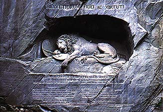 "Lion
Monument," a massive sculpture in rock honoring 700 Swiss soldiers who were killed
while attempting to save the life of a King Louis XVI in 1792 (who had fled Paris
without mentioning it to the Swiss soldiers). The sculpture shows a dying lion with a
knife between his ribs lying in agony upon two shields: one with the French fleur-de-lis
and the other with the Swiss cross. Below that are the names of the soldiers who died
for the honor of Switzerland. It was surprisingly moving, even to those of us who are
non-Swiss nor knew much about the history of the events; and
"Lion
Monument," a massive sculpture in rock honoring 700 Swiss soldiers who were killed
while attempting to save the life of a King Louis XVI in 1792 (who had fled Paris
without mentioning it to the Swiss soldiers). The sculpture shows a dying lion with a
knife between his ribs lying in agony upon two shields: one with the French fleur-de-lis
and the other with the Swiss cross. Below that are the names of the soldiers who died
for the honor of Switzerland. It was surprisingly moving, even to those of us who are
non-Swiss nor knew much about the history of the events; and
- We managed to connect with Eugene Pan, a friend from Boulder who is working
temporarily in Milan (two and half hours away). Together we spent the afternoon
walking across and through the Tower Wall, up to the fabulous Guitsch Hotel
that overlooks the city, through the old city, took pictures to verify
our meeting, and finally parted at 5:30 for the return train ride to Engelberg.
We got off the train at the station before Engelberg and walked along the
river for the last three miles to the hotel.
Rutli Meadows
There is some controversy among historians about whether or not representatives
of the three rebellious cantons--Uri, Schwyz, and Unterwalden--in fact met in
this particular pasture above Lake Lucerne to form the original
 confederation of cantons that later become Switzerland. That they did meet on
August 1, 1291, and signed the "Rutli Oath" is well documented. Where the
event took place doesn't seem to really matter to most Swiss who come here
to pay their respects to the origins of the country. Besides, it's a beautiful
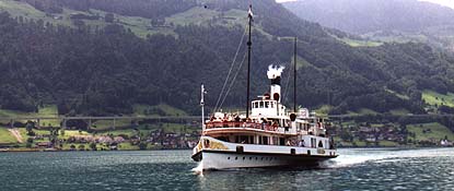
spot and an easy walk to the lake to board one of the fifteen steamers that take
folks around Lake Lucerne (on Swiss maps it's called "Vierwaldstattersee,"
which means "the lake of the four forest cantons") from one town to another.
Along the way, you can stop to visit the William Tell Chapel and a monument
to Friedreich Von Schiller, whose 1805 drama, "Wilhelm Tell," put the Tell legend
in the history books, so to speak. In 1991, to honor the 700 years since the
confederation, 26 markers--one for each canton and half canton--were placed
from Rutli to Urnersee separated by a distance calculated at five centimeters
(?) for every resident of that canton, and in order of the canton's date of
joining the confederation.
confederation of cantons that later become Switzerland. That they did meet on
August 1, 1291, and signed the "Rutli Oath" is well documented. Where the
event took place doesn't seem to really matter to most Swiss who come here
to pay their respects to the origins of the country. Besides, it's a beautiful
spot and an easy walk to the lake to board one of the fifteen steamers that take
folks around Lake Lucerne (on Swiss maps it's called "Vierwaldstattersee,"
which means "the lake of the four forest cantons") from one town to another.
Along the way, you can stop to visit the William Tell Chapel and a monument
to Friedreich Von Schiller, whose 1805 drama, "Wilhelm Tell," put the Tell legend
in the history books, so to speak. In 1991, to honor the 700 years since the
confederation, 26 markers--one for each canton and half canton--were placed
from Rutli to Urnersee separated by a distance calculated at five centimeters
(?) for every resident of that canton, and in order of the canton's date of
joining the confederation.
SOME LASTING IMAGES
- All the picture postcards from Switzerland are
accurate. The cities are wonderful, the mountains are gorgeous, and many
people live very traditionally. Brown Swiss cows are everywhere; Heidi's
grandfather's alp hut is a fact of life; medieval castles, churches, towers,
and walls stand side by side with modern designs and constructions; Swiss
watches and Swiss Army Knives, chocolate and cheeses, and cuckoo clocks
are sold everywhere (though not at great bargain prices). We found every
romantic image we had of the country to be true.
- The Swiss seem to live well. There are no "old" cars; they're simply not
permitted. We saw no slums, no derelict houses, no beggars or "street people."
Houses, as well as barns, sheds, outbuildings and the like may be old, but they
are very well maintained, Many are decorated with window flower boxes (geraniums
seem the overwhelming flower of choice). Income levels are on a par with ours
(e.g., teachers' salaries begin at about the equivalent of US$35,000) and their
level of taxation is also about the same as ours, though the number of taxes are
fewer and more easily identified. Life seems good in Switzerland.
- The country is spotless: public rest rooms in towns, restaurants, and train
stations are cleaner than some homes we've been in. Many people in cities, on
trails, and in rural areas have dogs, yet we didn't see a single pile of dog
poop anywhere. And all this in a country where pig poop is as important as the
pigs: it is gathered, liquefied, and sprayed on the fields. How else do those
fields stay so green?
- Train travel is easy, punctual, and everywhere in Switzerland between
cities and towns and villages
 and waysides. If you go on your own, don't bother
to rent a car. You should, however, plan on walking more than you might
be used to: it's the only way to really see the cities, and hiking paths
in the countryside are everywhere and accurately marked.
and waysides. If you go on your own, don't bother
to rent a car. You should, however, plan on walking more than you might
be used to: it's the only way to really see the cities, and hiking paths
in the countryside are everywhere and accurately marked.
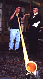
- The alphorn, (shown on the left) that long (10'-12') instrument
you see in the Ricola commercials, is capable of producing simple and melodic
tunes despite its lack of valves (like on a trumpet) or holes (like a clarinet).
It's about as hard to play as a hose. (Try it for yourself: Cut a hose to a
length of ten or twelve feet, insert a mouthpiece from a trumpet in one end,
and you can play simple tunes. It just takes some practice. And lots of
breath.)
- When in Switzerland, don't ask for Swiss cheese. You'll
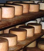 get a funny look and be told that all
the cheese in the case is Swiss. Duh! Although the markets and shops in towns,
in big cities, at the airport--everywhere--sell good cheeses, the best place to
buy cheese may be on the hillside, like the one we stopped at above Engelberg.
The milk was probably raw and the health department may not have been around
recently, the place was lick-the-floor clean and the cheeses, from both cow and
goat milk, were wonderfully mild and tasty. We ate more cheese in our two weeks
than we ate the two years before. In addition to great cheeses, the Swiss beers
(especially Appenzeller Bier)
are outstanding, and the breads may be the best anywhere in the world.
get a funny look and be told that all
the cheese in the case is Swiss. Duh! Although the markets and shops in towns,
in big cities, at the airport--everywhere--sell good cheeses, the best place to
buy cheese may be on the hillside, like the one we stopped at above Engelberg.
The milk was probably raw and the health department may not have been around
recently, the place was lick-the-floor clean and the cheeses, from both cow and
goat milk, were wonderfully mild and tasty. We ate more cheese in our two weeks
than we ate the two years before. In addition to great cheeses, the Swiss beers
(especially Appenzeller Bier)
are outstanding, and the breads may be the best anywhere in the world.
- European Walking Tours, the organization
in charge of the trip on behalf of Elderhostel, apparently specifies that no matter
the location, breakfasts must always (and only) consist of dry cereal, bread, yogurt,
fruit, cheese, juice, coffee, and tea. Lunches must consist of one sandwich, one
piece of fruit, and one chocolate bar of some sort.
- The gasthaus is a wonderful tradition that is too rarely found in this country.
Perhaps there are too few hikers/walkers/mountain bikers in the country to warrant
these out of the way mountain restaurants with rooms to rent? Several years ago we
mountain biked to a ski hut rented out to a restaurant during the summer near the
top of Shrine Pass here in Colorado to enjoy a magnificent meal in an outstanding
setting. We thought we'd found something unique, but it is clearly in the tradition
of the Swiss (European?) gasthaus.
Our thanks to the other members of the Elderhostel group for making our two weeks
so enjoyable, 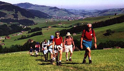 especially to our fellow hikers: to Ray who set a steady pace and kept us moving;
to Ann and Philip who kept thoughtful conversation flowing and always saw
the light side of things; to Bob and Dace who enthusiastically shared their
previous hiking trips with us; to Diane for her abilities to see through
the camera's lens; and to her brother, Ray, who has promised to visit us
in Colorado to do some high altitude hiking here in Nederland.
especially to our fellow hikers: to Ray who set a steady pace and kept us moving;
to Ann and Philip who kept thoughtful conversation flowing and always saw
the light side of things; to Bob and Dace who enthusiastically shared their
previous hiking trips with us; to Diane for her abilities to see through
the camera's lens; and to her brother, Ray, who has promised to visit us
in Colorado to do some high altitude hiking here in Nederland.
In fact, the invitation goes out to you all. We think if you liked Switzerland,
you're bound to like our area. Just take a look at the picture on our home
page: doesn't that photograph of Nederland look a little like Switzerland?
Come see for yourself.
