GLACIER NATIONAL PARK
July 16–24, 2004


I. THE BIG PICTURE

        Montana's Glacier National Park was the site of our 8th annual reunion with Judy's high school girl friends. Via interstate highways, it's about 1,000 miles from here, but we decided to take an extra day or two both going and returning to see parts of Wyoming and Idaho we hadn't seen or not seen in over 30 years. We drove north to Cheyenne and west to Green River for the first night; then to Kemmerer (Wyoming), Fossil Butte National Monument, and Pocatello for the second night; and then north through Challis and Salmon, across Lost Trail Pass into Montana to Missoula, the Flathead Valley, and finally to Whitefish that would be our base for the next five nights.


II. ON THE ROAD TO GLACIER
judyrunning •Green River. We took the fast lanes across southern Wyoming. The wet spring and summer had turned the rolling countryside—usually dry-grass brown—into a green blanketed grassland unusual for mid-July. We stopped in Green River early enough to bike through this small railroad town on their system of bike paths that run through town and skirt the Green River. As 
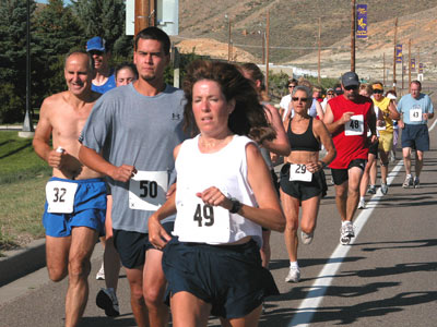
we were heading back to the motel, we noticed an sign announcing a 5K race the following morning. After several phone calls, we learned the location and time of the race in the morning. Registration was $10 which included a T-shirt, age group prizes, a raffle of gift certificates, and a timer. At 8:00 a.m. the sun was already strong and hot, and the route was deceptively challenging: gentle but long uphills and a couple of striking downhills along the way. Number 29 was the 4th woman and won the women's 50+ age group.

•Kemmerer. This quiet, charming, off-the-main-road town is home to the first JC Penney store in the country. Known as the "Mother Store," it exists not as a museum (though it remains very true to the original store James Cash Penney established in 1902) but it reminded us of small town retail department stores from our childhood of the 1940s. Kemmerer and its sister town, Diamondville, have a history rooted in farming, mining (coal) and fossils. In fact, Kemmerer is known as the "Fossil Fish Capital of the World." Some of the most spectacular specimens of mother store 
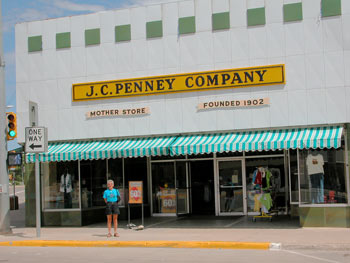
fossil fish and palms are on display in town and at the the Fossil Butte National Monument just west of town. Kemmerer is also home to the annual Oyster Ridge Music Festival, the state's largest free music festival. This three-day event each July features bluegrass and Celtic bands with performers from the USA and Canada.

Fossil Butte National Monument. Wyoming's often drab landscape masks a fascinating and complex geologic history. Most of the state was at the bottom of an ancient ocean that left stratified sediments several miles thick. Within the layers of earth are the remains of ancient plants and animals of the Paleozoic and Mesozoic eras. As a result, Wyoming's coal and petroleum deposits are among the richest in the country, and fish, plant, and dinosaur fossils can be found in many places around the state. At Fossil Butte NM we were able to watch expert and amateur archeologists uncover fish and plant fossils from a small cut in the side of a hill. Each find is numbered, measured, described, and fossil butte 
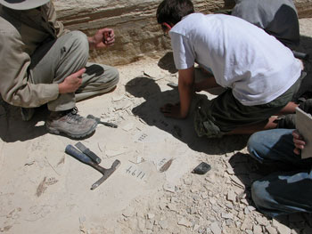
recorded, including the individual—visitor or on-site expert—who discovered the fossil.

•Challis and Salmon. Over 30 years ago, we had traveled in our VW bus through these two towns that flank the Salmon River. In fact, a mechanical breakdown forced us to stay in Salmon for nearly a week while repairs could be made by Fritz, a German-born mechanic who worked at the local Nash Rambler dealer! We were interested to see if our memories of these two towns fit current realities. Of course they didn't: Salmon was not the interesting small town we got to know so well, and Challis was much more interesting to us this trip, especially as the gateway to mining ghost towns (Bonanza, Custer, Bayhorse) located on the Yankee Fork Historic Loop (still a dirt road) that runs south out of town to the Stanley Basin, one of the state's scenic gems. We'll be sure to return there to spend more time camping and poking around this area.

•Flathead Lake. North of Darby (pricey antiques stores), Stevensville (oldest town in Montana), and Missoula (a beautiful city of 57,000 and the home of the University of Montana—the "Grizzlies" who rank fifth in the nation among public colleges producing Rhodes Scholars) is the Flathead Valley, an area of great scenic beauty, cherries and huckleberries, great fishing and boating, and home of the largest freshwater lake west of the Mississippi. For old times' sake, we drove up the east side of the lake to see if we could locate a piece of property we had nearly purchased over 30 years ago. At that time, we had put an offer on 200' of lakeshore on the east side of Flathead Lake for the then-handsome sum of $20,000, an amount that would have severely stretched the budget of a new assistant professor and his stay-at-home wife and mother of two small children. Of course we didn't find the property on this trip, but we did notice in a local real estate flyer someone was offering 134' feet of lake shore on the same side of Flathead Lake for a now very handsome sum of $550,000.
map of glacier
•Whitefish/Big Mountain Resort. Our home while visiting Glacier National Park was 3-bedroom condo just outside of Whitefish at Big Mountain Resort. Though the resort may be trying hard to be a year round destination, Big Mountain seems to be primarily a ski resort; there were no throngs of visitors while we were there. The potential is there: there are attractive trails for hiking and mountain biking, the gondola runs all day to take folks to the top of the mountain for views of the Flathead Valley and Whitefish Lake, and shops and restaurants are open. But there seemed at least as many workers and employees as visitors. We enjoyed the relative quiet of the area.
   
III. GLACIER NATIONAL PARK

        We arrived well before the other two couples and decided to spend the day biking through the North Fork Section of the Park. To get there, we drove to Columbia Falls and then 35 miles of mostly dirt road north to the northwestern entrance of the park at Polebridge. Polebridge surprised us: it is a former "town" built around a hotel in 1910 to accommodate travelers to this remote section of the park. The building is now a general store with a scattering of houses and trailers that accommodate seasonal visitors/residents. The store features outstanding breads and pastries baked fresh daily. Who'd have thought that at the end of a long dusty drive, that we could treat ourselves to fresh bread at such a lonely outpost of humanity?
   
        We crossed into the park a mile beyond Polebridge and set out for Kintla Lake, 15 miles away and just a stone's throw from the Canadian border (It's the narrow lake in the upper left hand corner of the park as shown on the map.) The dirt road was rough but flat and crossed through open meadows with great views of the mountains to the east. We saw deer as well as signs of the fires that devastated the area last year. Halfway there, the white, fair weather cumulus clouds darkened and we decided to abort the bike ride. stort at polbridge 
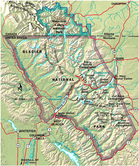
And a good thing we did: less than an hour later, on the drive back, the heavens opened up and demonstrated why this part of the country is so green
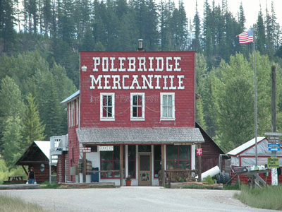
 in the summer.

        By the time we returned, one of the other couples had already arrived and the other couple came soon after. We had a good dinner in Whitefish, shopped at the local Safeway, and made plans for the three full days we had to enjoy Glacier and our time together.


•Hiking the Park. With over 700 miles of trails, Glacier is a paradise for horseback riding, hikers, walkers, strollers, backpackers, trekkers, and others who travel by foot. We discovered, however, that trails are poorly marked and maps big horn sheep 
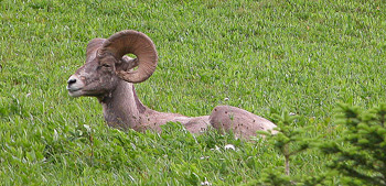
do not often help to locate trailheads or to decide which fork to take. We spent our first day in the west side of the Park—West Glacier Village, Lake McDonald, and eventually to the "halfway" point in the park: Logan Pass (6,646'). Along the Going to the Sun Road, we stopped to see waterfalls, to walk along the Flathead River, to photograph the not so shy mountain goats and majestic bighorn sheep that pose for visitors on a trail near Logan Pass. We also stopped for conversations with road workers who held up traffic at half a dozen locations along this much used narrow mountain road through the Park. We did not get into the back country where grizzlies, elk, moose, and other large mammals dominate (in fact, we never saw an elk or moose, and the only bear we saw was on a highway outside the park), but we'll save that for another trip. We only hope that the weather then will be as fine and fair as it was this time.

whitewater
•Rafting the Park. There are several companies that take groups down the Middle Fork of the Flathead River. For our main activity on the second day we chose the Montana Raft Company who gave us a good half day trip (and took this photo; we're the back three on either side of the boar). We had plenty of chances to get wet in the class II-III rapids or getting splashed by a rival group of rafters. While the six of us may not hike often or far, we do enjoy water—whether we're poolside at a Puerto Vallarta resort, walking the shore of Lake Tahoe, or whitewater rafting in the mountains.
       
        When we returned to the Big Mountain condo, we packed a picnic of cheese, crackers, wine, and tequila and rode the gondola to the top of the mountain for relaxing snack and a 360 degree view of the mountains and valleys and the setting sun. Dinner at a restaurant on the mountain was a perfect end to a perfect day. 
       

•Driving the Park. In addition to enjoying water activities, we also seem to do a good bit of driving when we get together, at least we did on this trip. Because it's such a large park (50 miles across the Going to the Sun Road, nearly 150 miles from the Canadian border to the south boundary; over 1 million acres), driving across and around the perimeter of the park is one way to get a sense of its size and diversity. Thankfully, one of the couples drove out in a comfortable six-passenger SUV.
hotel
        We crossed Logan Pass to St. Mary Lake on the east side, then out of the park and north to Canada's adjoining Waterton Lakes National Park which joined with Glacier, in 1932, to create Waterton/Glacier International Peace Park, the first international park in the world. We were a bit nervous about crossing into Canada because we had heard, erroneously as it turned out, that visitors now had to show an American passport. One area resident said that "it depends on who you get at the crossing station." We needn't have worried: we showed our driver's licenses answered the usual questions, and went on our way to Waterton Lakes. (Our return crossing was also a non-event.)
       
        We had lunch at the fabulous Prince of Wales Hotel which overlooks Waterton Lakes. It is one of those grand mountain lodges, like those at Banff, Grand Canyon, Yosemite, Yellowstone, et al. built to attract wealthy visitors to national parks. In this case, the Great Northern Railway pushed for the creation of the hotel which opened in 1927. Lunch, served in the grand dining room by a young man in a kilt, was not as formal or dressy an affair as it probably was a generation or two ago. But the ambiance was elegant and the view spectacular.

        After lunch we strolled through the peaceful lakeside village of Waterton, gateway to one of Canada's most beautiful parks.

        On the return to Whitefish we drove on US 2 the eastern, southern and southwest perimeters of the park, through St. Mary and Kiowa to East Glacier to visit the East Glacier Lodge which, like the Prince of Wales Hotel, was built in 1913 on a grand scale by the Great Northern Railway just three years after the Park was created. An Amtrak station now sits across the street from the hotel where passengers from around the country disembark for a truly western mountain experience that combines gracious living with forays into the Rocky Mountains wilderness. After a day of horseback riding, or touring in one of the park's unique historic red jammer buses, or hiking in the back country, guests can return to swim in the lodge's heated pool, play a round of golf, or enjoy drinks on stair photo 
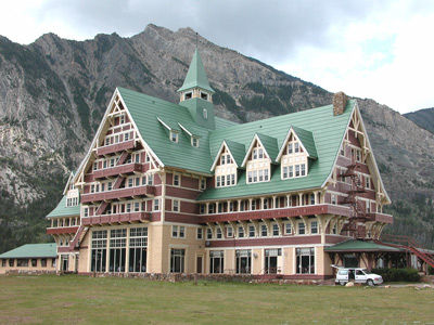
the patio to watch the sun go down over the Livingston Range to the west. Reservations are almost certainly required! We marveled at the magnificent three story lobby supported by massive beams carved from trees hundreds of years old.


 IV. RETURNING HOME
     
    Before leaving we took several different "stair pictures," an annual tradition. The best of the bunch this year showed only the wives. The husbands' photo below was taken with St. Mary Lake in the background. 

        The (almost) four days together passed too quickly and our time together was probably a bit more intense than we anticipated. While we didn't explore the Park as fully as we would have liked, the visit made us determined to return soon for more biking, camping, hiking, and time in the back country. However, we did what we really came for: to renew old friendships and catch up on each other's activities and families over the past year. We looked at photos of grandchildren and trips to Italy and New Zealand; we talked about health insurance, retirement funds, aches and pains, and other things old folks talk about when they get together. And we talked about seeing each other again next year in New Hope, Pennsylvania, for the wives' 45th high school reunion.

        Our trip home was more direct than we had originally planned. Much of it was by interstate highway, though the stretch from Whitefish to Billings took ushusbands through or on the fringe of some of Montana's most scenic areas, with names that conjure images of the mining frenzy that brought European Americans to this wild land with the promise of fortunes to be dug from the earth: the Garnet Range, Stone, and Opportunity; ghost towns of Phillipsburg, Garnet, and Virginia City. Butte, once the richest copper mining area in the country has lost its economic base (the 1700' deep Berkley Pit is a stark reminder of those former mining days), but the city seems to be making a comeback through promoting its history and the area's natural beauty. Hot springs can be found around almost every bend in the road—Sleeping Child Hot Springs, Bozeman Hot Springs, Chico Hot Springs— leading to the mother of all hot springs at Yellowstone to the south. US Highway 212 that runs southwest from Billings through Red Lodge past Granite Peak (high point in the state at 12,799') to Yellowstone is considered by many to be the most beautiful road in the country. All this waits for another trip.

        Instead, we realized we were weary of car travel and yearned to be home. On the way down the interstate, we briefly visited Butte and spent the night in Billings, the state's biggest city (population about 67,000) that marks the division between the prairie grasslands of eastern Montana and the green slopes of the Rockies to the west. In the morning we calculated that we could be at Michael and Cindy's to pick up the dogs and still be home before the ten o'clock news: I-90 to Sheridan, I-25 at Buffalo, a beautiful back road detour on state road 487 from Casper to Laramie, and finally down US 287 through Ft. Collins to I-25 to Lafayette.

        We learned where we'd like to return and that we need to explore it all at a more leisurely pace. The roads are not too steep for our mini-motor home. Look for Sophie and Bella to join us in Montana sometime next year.


Judy and Hughes Moir
Home Email H&J Letters USA Travels Foreign Travels